IMAGES TAKEN NEAR TO
Coppermill Road, STAINES-UPON-THAMES, TW19 5NW
Introduction
This page details the photographs taken nearby to Coppermill Road, TW19 5NW by members of the Geograph project.
The Geograph project started in 2005 with the aim of publishing, organising and preserving representative images for every square kilometre of Great Britain, Ireland and the Isle of Man.

There are currently over 7.5m images from over14,400 individuals and you can help contribute to the project by visiting https://www.geograph.org.uk
Image Map
Images are licensed for reuse under creativecommons.org/licenses/by-sa/2.0
Notes
- Clicking on the map will re-center to the selected point.
- The higher the marker number, the further away the image location is from the centre of the postcode.
Image Listing (13 Images Found)
Images are licensed for reuse under creativecommons.org/licenses/by-sa/2.0
Image
Details
Distance
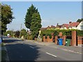
2
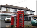
Phone box and shops on Coppermill Road, Wraysbury
Image: © David Howard
Taken: 2 Nov 2014
0.06 miles
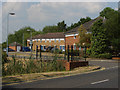
3
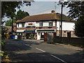
Shops, Horton Village
Shops near the southern end of Horton Village on Coppermill Road.
Image: © Alan Hunt
Taken: 17 Jul 2013
0.07 miles

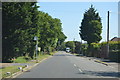
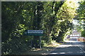
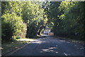
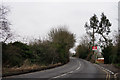
5
Coppermill Road, Horton
Looking north along the road that runs from Wraysbury to Poyle to the west of the Wraysbury reservoir
Image: © Alan Hunt
Taken: 5 Sep 2013
0.10 miles
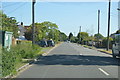
8
Old Mill Place
A new development off Coppermill Road
Image: © Alan Hunt
Taken: 17 Jul 2013
0.17 miles
9
Wraysbury
Entrance to the railway station, seen from Station Road.
Image: © Peter Trimming
Taken: 11 Feb 2015
0.19 miles