IMAGES TAKEN NEAR TO
Station Road, STAINES-UPON-THAMES, TW19 5NN
Introduction
This page details the photographs taken nearby to Station Road, TW19 5NN by members of the Geograph project.
The Geograph project started in 2005 with the aim of publishing, organising and preserving representative images for every square kilometre of Great Britain, Ireland and the Isle of Man.

There are currently over 7.5m images from over14,400 individuals and you can help contribute to the project by visiting https://www.geograph.org.uk
Image Map
Images are licensed for reuse under creativecommons.org/licenses/by-sa/2.0
Notes
- Clicking on the map will re-center to the selected point.
- The higher the marker number, the further away the image location is from the centre of the postcode.
Image Listing (31 Images Found)
Images are licensed for reuse under creativecommons.org/licenses/by-sa/2.0
Image
Details
Distance
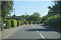
1
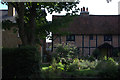
Houses in Station Road, near Wraysbury station
Image: © Robert Eva
Taken: 31 Jul 2017
0.02 miles
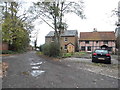

5
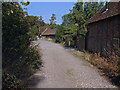
Old farm buildings, Wraysbury
Old barns alongside the footpath from Station Road to the High Street.
Image: © Alan Hunt
Taken: 5 Sep 2013
0.06 miles
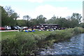
8

Divers in the Water
The lake at Wraysbury Dive Centre
Image: © Martyn Davies
Taken: 11 Apr 2016
0.10 miles
9
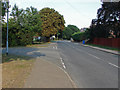
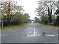
Douglas Lane junction
The junction of Douglas Lane with Station Road on the outskirts of Wraysbury village.
Image: © Alan Hunt
Taken: 5 Sep 2013
0.10 miles