IMAGES TAKEN NEAR TO
Friary Island, STAINES-UPON-THAMES, TW19 5JR
Introduction
This page details the photographs taken nearby to Friary Island, TW19 5JR by members of the Geograph project.
The Geograph project started in 2005 with the aim of publishing, organising and preserving representative images for every square kilometre of Great Britain, Ireland and the Isle of Man.

There are currently over 7.5m images from over14,400 individuals and you can help contribute to the project by visiting https://www.geograph.org.uk
Image Map
Images are licensed for reuse under creativecommons.org/licenses/by-sa/2.0
Notes
- Clicking on the map will re-center to the selected point.
- The higher the marker number, the further away the image location is from the centre of the postcode.
Image Listing (94 Images Found)
Images are licensed for reuse under creativecommons.org/licenses/by-sa/2.0
Image
Details
Distance
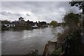

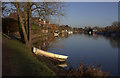
3
Walk along the Thames from Runnymede to Old Windsor (57)
Image: © Basher Eyre
Taken: 6 Aug 2011
0.02 miles
4
Modern house on stilts beside the Thames on Friary Island
Image: © Eirian Evans
Taken: 27 Nov 2013
0.02 miles
5
Walk along the Thames from Runnymede to Old Windsor (68)
Image: © Basher Eyre
Taken: 6 Aug 2011
0.03 miles
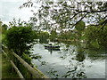
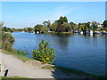
6
The Thames at Old Windsor
Looking upstream from the Thames Path
Image: © Robert Eva
Taken: 5 Jan 2017
0.04 miles
7

Yacht and modern house on the bank of The Thames
Image: © Richard Humphrey
Taken: 5 Aug 2018
0.04 miles
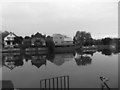
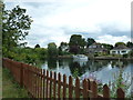
8
Old Windsor riverside
Looking across the Thames from the Thames Path to Ferry Island.
Image: © Eirian Evans
Taken: 14 Oct 2011
0.04 miles
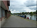
9
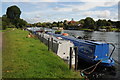
The Thames at Old Windsor
Narrow boats moored on the banks of the River Thames at Old Windsor.
Image: © Philip Halling
Taken: 29 Aug 2011
0.05 miles
10
Walk along the Thames from Runnymede to Old Windsor (69)
Image: © Basher Eyre
Taken: 6 Aug 2011
0.05 miles