IMAGES TAKEN NEAR TO
Welley Road, STAINES-UPON-THAMES, TW19 5HQ
Introduction
This page details the photographs taken nearby to Welley Road, TW19 5HQ by members of the Geograph project.
The Geograph project started in 2005 with the aim of publishing, organising and preserving representative images for every square kilometre of Great Britain, Ireland and the Isle of Man.

There are currently over 7.5m images from over14,400 individuals and you can help contribute to the project by visiting https://www.geograph.org.uk
Image Map
Images are licensed for reuse under creativecommons.org/licenses/by-sa/2.0
Notes
- Clicking on the map will re-center to the selected point.
- The higher the marker number, the further away the image location is from the centre of the postcode.
Image Listing (24 Images Found)
Images are licensed for reuse under creativecommons.org/licenses/by-sa/2.0
Image
Details
Distance
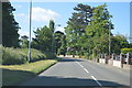
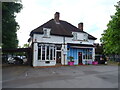
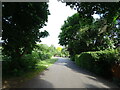
3
Wraysbury
Welley Road, by the junction with English Gardens.
Image: © Peter Trimming
Taken: 11 Feb 2015
0.04 miles
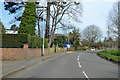
5
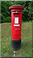
George V postbox on Welley Road, Sunnymeads
Postbox No. TW189 608.
Image: © JThomas
Taken: 27 May 2022
0.05 miles
6
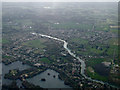
Wraysbury from the air
Wraysbury is surrounded by water (including the River Thames seen here) and was badly affected by the floods on February 2014 as can be seen in this BBC Newsnight video http://www.bbc.com/news/uk-26165914 .
See also Image
Image: © Thomas Nugent
Taken: 18 Mar 2014
0.06 miles
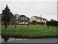
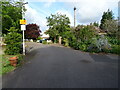
10
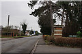
Wraysbury
Welley Road, by the junction with The Drive.
Image: © Peter Trimming
Taken: 11 Feb 2015
0.13 miles