IMAGES TAKEN NEAR TO
Welley Avenue, STAINES-UPON-THAMES, TW19 5HE
Introduction
This page details the photographs taken nearby to Welley Avenue, TW19 5HE by members of the Geograph project.
The Geograph project started in 2005 with the aim of publishing, organising and preserving representative images for every square kilometre of Great Britain, Ireland and the Isle of Man.

There are currently over 7.5m images from over14,400 individuals and you can help contribute to the project by visiting https://www.geograph.org.uk
Image Map
Images are licensed for reuse under creativecommons.org/licenses/by-sa/2.0
Notes
- Clicking on the map will re-center to the selected point.
- The higher the marker number, the further away the image location is from the centre of the postcode.
Image Listing (33 Images Found)
Images are licensed for reuse under creativecommons.org/licenses/by-sa/2.0
Image
Details
Distance
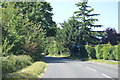
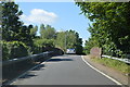
4
Welley Road - B376
Lights for the narrow bridge over the railway by Sunnymeads Railway Station.
Image: © Fernweh
Taken: 11 Feb 2012
0.06 miles
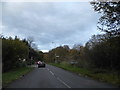
5
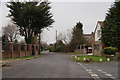
Sunnymeads
The Avenue, seen from the end of Acacia Avenue.
Image: © Peter Trimming
Taken: 11 Feb 2015
0.07 miles
6
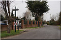
Sunnymeads
The Avenue, seen from the end of Acacia Avenue.
Image: © Peter Trimming
Taken: 11 Feb 2015
0.08 miles
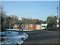
8
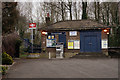
Sunnymeads Railway Station
Located at the end of Acacia Avenue.
Image: © Peter Trimming
Taken: 11 Feb 2015
0.11 miles
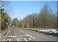
10
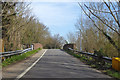
Railway bridge on B376 Welley Road
The line crossed is the branch from Staines to Windsor Riverside. The road is alternately one-way, controlled by lights.
Image: © Robin Webster
Taken: 22 Mar 2020
0.12 miles