IMAGES TAKEN NEAR TO
Welley Road, STAINES-UPON-THAMES, TW19 5DW
Introduction
This page details the photographs taken nearby to Welley Road, TW19 5DW by members of the Geograph project.
The Geograph project started in 2005 with the aim of publishing, organising and preserving representative images for every square kilometre of Great Britain, Ireland and the Isle of Man.

There are currently over 7.5m images from over14,400 individuals and you can help contribute to the project by visiting https://www.geograph.org.uk
Image Map
Images are licensed for reuse under creativecommons.org/licenses/by-sa/2.0
Notes
- Clicking on the map will re-center to the selected point.
- The higher the marker number, the further away the image location is from the centre of the postcode.
Image Listing (41 Images Found)
Images are licensed for reuse under creativecommons.org/licenses/by-sa/2.0
Image
Details
Distance
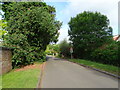
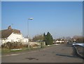
3
Fairfield Approach
A residential road off Welley Road with a good view of the leaning telegraph pole of Wraysbury.
Image: © Alan Hunt
Taken: 19 Aug 2013
0.06 miles
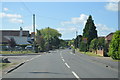
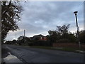
5
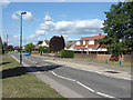
Welley Road
Welley Road from the junction of Fairfield Approach.
Image: © Alan Hunt
Taken: 19 Aug 2013
0.06 miles
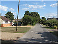
7
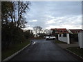
Old Ferry Drive, Wraysbury
Being a private road you will not see this on Streetview
Image: © David Howard
Taken: 2 Nov 2014
0.11 miles
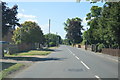
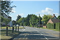
9

Old Ferry Drive junction
The junction of Old Ferry Drive with Welley Road.
Image: © Alan Hunt
Taken: 19 Aug 2013
0.11 miles