IMAGES TAKEN NEAR TO
Broadwater Close, STAINES-UPON-THAMES, TW19 5BZ
Introduction
This page details the photographs taken nearby to Broadwater Close, TW19 5BZ by members of the Geograph project.
The Geograph project started in 2005 with the aim of publishing, organising and preserving representative images for every square kilometre of Great Britain, Ireland and the Isle of Man.

There are currently over 7.5m images from over14,400 individuals and you can help contribute to the project by visiting https://www.geograph.org.uk
Image Map
Images are licensed for reuse under creativecommons.org/licenses/by-sa/2.0
Notes
- Clicking on the map will re-center to the selected point.
- The higher the marker number, the further away the image location is from the centre of the postcode.
Image Listing (19 Images Found)
Images are licensed for reuse under creativecommons.org/licenses/by-sa/2.0
Image
Details
Distance
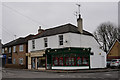
2
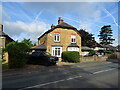
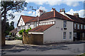
Wraysbury - Old Houses on Staines Road
The right semidetached house was built in 1901. The left house is older.
Image: © James Emmans
Taken: 26 Feb 2017
0.05 miles
4
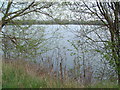
Silver Wing Lake
This former gravel pit is the home of the British Airways Sailing Club. More details can be found at http://www.silverwing.org.uk
Image: © David Squire
Taken: 21 Apr 2006
0.12 miles
5
The Oast Barn, Staines Road, Wraysbury
A coach house, stables and grooms' cottages once part of a large estate owned by the Doulton family, and converted to a house in the 1950's, and now used as a bed and breakfast.
Up until the eighteenth century part of it was a public house called 'The Hope and Despair'.
Image: © Oast House Archive
Taken: 16 Jul 2009
0.17 miles
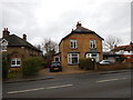
6
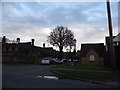
Old School Close at the junction of Staines Road
Image: © David Howard
Taken: 2 Nov 2014
0.17 miles
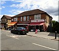
7
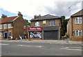
Alexandra Villas
The building on Staines Road is now occupied by Wraysbury News and R K Leisure. The latter operate fishing lakes including Wraysbury Nature Reserve https://www.rkleisure.com/history/wraysbury-1/
Image: © Gerald England
Taken: 17 Jul 2018
0.17 miles
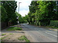
8
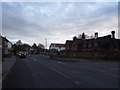
Staines Road, Wraysbury
Entering the village centre
Image: © David Howard
Taken: 2 Nov 2014
0.18 miles
9
Wraysbury
Junction of Windsor Road with High Street.
Image: © Peter Trimming
Taken: 11 Feb 2015
0.20 miles
10
Wraysbury Post Office
Part of Sai News and next door to Karellies Cafe the Pennyfields hardware store.
Image: © Gerald England
Taken: 17 Jul 2018
0.20 miles