IMAGES TAKEN NEAR TO
The Island, STAINES-UPON-THAMES, TW19 5AS
Introduction
This page details the photographs taken nearby to The Island, TW19 5AS by members of the Geograph project.
The Geograph project started in 2005 with the aim of publishing, organising and preserving representative images for every square kilometre of Great Britain, Ireland and the Isle of Man.

There are currently over 7.5m images from over14,400 individuals and you can help contribute to the project by visiting https://www.geograph.org.uk
Image Map
Images are licensed for reuse under creativecommons.org/licenses/by-sa/2.0
Notes
- Clicking on the map will re-center to the selected point.
- The higher the marker number, the further away the image location is from the centre of the postcode.
Image Listing (83 Images Found)
Images are licensed for reuse under creativecommons.org/licenses/by-sa/2.0
Image
Details
Distance
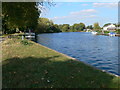
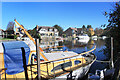
1
Boat in a Bad Way
A river cruiser in a sad state on the Thames at Egham.
Image: © Des Blenkinsopp
Taken: 4 Nov 2020
0.04 miles
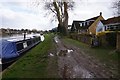
3
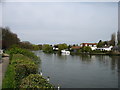
The River Thames at Hythe End
Seen from the Thames Path, on the extreme left.
Image: © David Purchase
Taken: 28 Apr 2013
0.06 miles
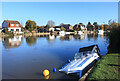
5
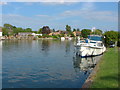
The Thames
A view of the Thames along the Hythe End reach.
Image: © Alan Hunt
Taken: 9 Aug 2012
0.07 miles
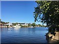
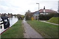
10
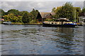
Baglady on the Thames near Hythe End
This hotel boat named Baglady often appears to be on the section of the River Thames I'm walking, here it is pictured near Hythe End.
Image: © Philip Halling
Taken: 29 Aug 2011
0.10 miles