IMAGES TAKEN NEAR TO
Mede Close, STAINES-UPON-THAMES, TW19 5AE
Introduction
This page details the photographs taken nearby to Mede Close, TW19 5AE by members of the Geograph project.
The Geograph project started in 2005 with the aim of publishing, organising and preserving representative images for every square kilometre of Great Britain, Ireland and the Isle of Man.

There are currently over 7.5m images from over14,400 individuals and you can help contribute to the project by visiting https://www.geograph.org.uk
Image Map
Images are licensed for reuse under creativecommons.org/licenses/by-sa/2.0
Notes
- Clicking on the map will re-center to the selected point.
- The higher the marker number, the further away the image location is from the centre of the postcode.
Image Listing (93 Images Found)
Images are licensed for reuse under creativecommons.org/licenses/by-sa/2.0
Image
Details
Distance
1
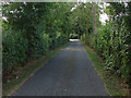
Magna Carta Lane
The access road that runs from the Staines Road to the Thames at Magna Carta Island.
Image: © Alan Hunt
Taken: 19 Aug 2013
0.07 miles
2
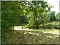
Gateway between fields
On the Ankerwycke National Trust property.
Image: © Robin Webster
Taken: 14 Jul 2017
0.08 miles
3
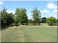
Field corner, Ankerwycke estate
The corner of one of the fields to the north of Magna Carta Lane.
Image: © Alan Hunt
Taken: 19 Aug 2013
0.08 miles
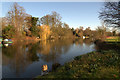
4
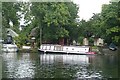
Boat at Runnymede
An interesting boat in the style of a Thames inspection launch, moored on the Wraysbury side of the river at Runnymede.
Image: © Graham Horn
Taken: 24 Aug 2008
0.10 miles
5
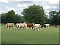
Ankerwycke, cows (and a bull)
The Ankerwycke estate is owned by the National Trust and includes Magna Carta Island and the remains of the Benedictine priory on the banks of the Thames. Most of the estate is farmed. Anne Boleyn stayed on the estate which was once owned by Sir Richard de Montfichet, one of the 25 barons present at the sealing of the Magna Carta.
Image: © Alan Hunt
Taken: 19 Aug 2013
0.10 miles
6
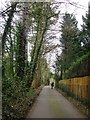
Magna Carta Lane approaching Magna Carta Island
There are - I believe - a few residences on the island at its upstream end, but there is no public access, and very little can be seen from the gate at the end of the lane.
Image: © Stefan Czapski
Taken: 19 Mar 2016
0.11 miles
7
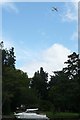
Boats and planes
No trains, but this section of river between Runnymede and Windsor is good for plane spotting, with regular departures from Heathrow airport turning quickly to the south (as here) or the north.
Image: © Graham Horn
Taken: 24 Aug 2008
0.12 miles
8
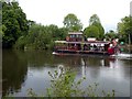
Paddle steamer on the River Thames at Runnymede
'Lucy Fisher', a replica of a Victorian paddle steamer, operates leisure trips on the river
Image: © Graham Hogg
Taken: 20 May 2017
0.13 miles
10
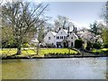
Magna Carta House
Situated on Magna Carta Island, the original house was built by George Simon Harcourt in 1834 to commemorate the signing* of Magna Carta in 1215. It has a large, early 20th century extension.
Magna Carta House is a grade II listed building (English Heritage Building ID: 40701 http://www.britishlistedbuildings.co.uk/en-40701-magna-carta-house-wraysbury-#.VS_pfWd0x_s British Listed Buildings).
*It has been pointed out to me that Magna Carta wasn't actually "signed" in that it doesn't carry any signatures. Mediæval kings authenticated documents by using the "Royal Seal" by an official called the spigurnel, using beeswax and resin. However the Oxford English Dictionary defines the verb "to sign" in this way: "To put a seal upon (a letter or document) as a means of identification or authentication; to stamp with a seal or signet; to cover with a seal." So, in a sense, King John did sign Magna Carta http://www.bbc.co.uk/news/blogs-magazine-monitor-30879124 .
Image: © David Dixon
Taken: 11 Apr 2015
0.13 miles