IMAGES TAKEN NEAR TO
Vicarage Lane, STAINES-UPON-THAMES, TW19 5AB
Introduction
This page details the photographs taken nearby to Vicarage Lane, TW19 5AB by members of the Geograph project.
The Geograph project started in 2005 with the aim of publishing, organising and preserving representative images for every square kilometre of Great Britain, Ireland and the Isle of Man.

There are currently over 7.5m images from over14,400 individuals and you can help contribute to the project by visiting https://www.geograph.org.uk
Image Map
Images are licensed for reuse under creativecommons.org/licenses/by-sa/2.0
Notes
- Clicking on the map will re-center to the selected point.
- The higher the marker number, the further away the image location is from the centre of the postcode.
Image Listing (17 Images Found)
Images are licensed for reuse under creativecommons.org/licenses/by-sa/2.0
Image
Details
Distance
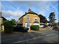
2
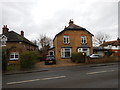
Wraysbury - Old Houses on Staines Road
The right semidetached house was built in 1901. The left house is older.
Image: © James Emmans
Taken: 26 Feb 2017
0.08 miles
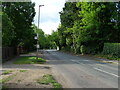
4
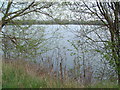
Silver Wing Lake
This former gravel pit is the home of the British Airways Sailing Club. More details can be found at http://www.silverwing.org.uk
Image: © David Squire
Taken: 21 Apr 2006
0.12 miles
5
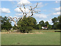
Stagshorn oak
A stagshorn oak in one of the fields owned by the National Trust with one of the houses off the Staines Road in the background.
Image: © Alan Hunt
Taken: 19 Aug 2013
0.14 miles
6
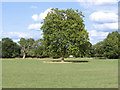
Plane tree, Ankerwycke estate
A London plane in one of the fields of the National Trusts Ankerwyke estate.
Image: © Alan Hunt
Taken: 19 Aug 2013
0.18 miles
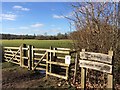
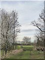
7
Footpath, Wraysbury
The footpath that runs across the fields from St Andrew's Church to the Ankerwycke estate.
Image: © Alan Hunt
Taken: 19 Aug 2013
0.18 miles
8
View towards Wraysbury church from Ankerwycke
View north across farmland from Runnymede Lane.
Image: © Stefan Czapski
Taken: 9 Mar 2017
0.19 miles
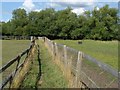
9
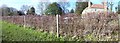
Ankerwycke Fence
This fence line shows how the hedge has been bent and woven to form a neat, sturdy, but living fence, which can still form a habitat for wildlife while enclosing land to ensure that the livestock does not access the road beyond.
Image: © Len Williams
Taken: 20 Feb 2013
0.19 miles