IMAGES TAKEN NEAR TO
Moor Lane, STAINES-UPON-THAMES, TW18 4YN
Introduction
This page details the photographs taken nearby to Moor Lane, TW18 4YN by members of the Geograph project.
The Geograph project started in 2005 with the aim of publishing, organising and preserving representative images for every square kilometre of Great Britain, Ireland and the Isle of Man.

There are currently over 7.5m images from over14,400 individuals and you can help contribute to the project by visiting https://www.geograph.org.uk
Image Map
Images are licensed for reuse under creativecommons.org/licenses/by-sa/2.0
Notes
- Clicking on the map will re-center to the selected point.
- The higher the marker number, the further away the image location is from the centre of the postcode.
Image Listing (190 Images Found)
Images are licensed for reuse under creativecommons.org/licenses/by-sa/2.0
Image
Details
Distance
1
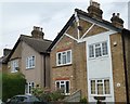
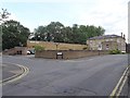
Great Western Cottages
Great Western Cottages on Moor Lane at Staines was home of Christine Keeler. According to The Telegraph, an article dated 8th November 2007 claims, “Christine Keeler used to entertain John Profumo in a disused railway carriage near here”. The affair between the two would eventually bring down Harold Macmillan's Conservative government. You can read more about "The Profumo Affair" at https://en.wikipedia.org/wiki/Profumo_affair
Image: © Sean Davis
Taken: 24 Aug 2012
0.05 miles
3
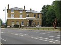
Staines: Former Staines West railway station (1)
When the Staines and West Drayton Railway completed their line into Staines in 1885 they converted this handy Georgian mansion house into the terminus station rather than constructing a new building. The line and the station were closed in 1965, and the building was converted into offices. For a view of the other side of the former station please see Image
The sculpture on the right is by the sculptor John Atkin and is entitled "Pound Mill".
Image: © Nigel Cox
Taken: 20 Jun 2010
0.09 miles
4
Staines: Former Staines West railway station (2)
This is the rear of Image Nick Catford's great website has an image of the station in 1968, three years after closure here http://www.disused-stations.org.uk/s/staines_west/index.shtml Evidently the railway was double-tracked virtually up to the building and had one platform on the left side of the current office car park. It is assumed that the buffers on the left here were originally at the end of the tracks. Some of the original rails are inbedded in the car park surface, although, again, not in their original locations.
Image: © Nigel Cox
Taken: 20 Jun 2010
0.09 miles
5
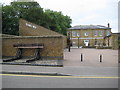
Staines West railway station (site), Surrey
Opened in 1885 by the Great Western Railway as the terminus of its short branch line from West Drayton, this station closed in 1965.
View south east from the road towards the site of the buffers, which were just in front of the still extant station building. The wall on which a new sign for "Staines West" has appeared is the original retaining wall at the rear of the platform. The lamp standards are also original from the platform but have been relocated to the centre of the car park. The buffer stop is a new addition since closure. For more detail, see http://www.disused-stations.org.uk/s/staines_west/index4.shtml
Image: © Nigel Thompson
Taken: 8 Jul 2019
0.09 miles
6
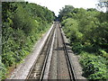
Railway lines between Windsor & Eton Riverside and Staines
Looking southeast towards Image
Image: © Mike Quinn
Taken: 8 Aug 2018
0.11 miles
7
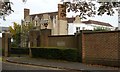
Duncroft Manor
Duncroft Manor can tell lots of stories, and holds many secrets from over the centuries. The present building dates from 1631 but has been changed through the years. The original house on the site is thought to have been Saxon and according to “Exploring Surrey’s Past” there is evidence of activity here during the Bronze Age and from Roman Times. Some sources claim that King John stayed here before sealing Magna Carta in 1215 at Runnymede. However, tradition claims it is more likely the Bishops and Barons stayed here the night before meeting King John at Runnymede on 15th June 1215 to seal Magna Carta. The Domesday Book (1086) mentions the Manor of Staines, and often the Manor House is referred to in other sources. However, there is no conclusive evidence to where the Manor House was. Duncroft is one place which could lay a claim, and excavations over the years have not disproved this.
Through the years Duncroft has been owned by many influential people including members of the Ashby brewing and banking family. Between 1948 and 1982 Duncroft was both a home and an approved school for girls. It was originally run by the Home Office, then the local authority and in October 1976 was then taken over by Dr Barnardo’s.
The girls here came from troubled backgrounds and from reading reports, plus blogs from girls who attended, many had high IQs. It was a requirement that girls entering Duncroft between 1962 and 1972 had an IQ in the top 10% of the population.
On a darker side, the old manor house has recently come to unveil some of its previously hidden secrets. Jimmy Savile (1926-2011) often visited in the early 1970s and it was through evidence given by some of the girls that The Metropolitan Police had set up an investigation named “Operation Yewtree” in 2012 to look into claims of sexual abuse by Jimmy Savile and others. You can read more about Duncroft Manor at https://sites.google.com/site/staineshistoricalwalks/home/staines-history-walk-part-1
Today Duncroft Manor is divided up into luxury flats.
Image: © Sean Davis
Taken: 9 Oct 2012
0.12 miles
8
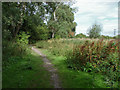
Path to the moor
The footpath that runs from the back of the Waters Drive recreation ground towards Staines Moor.
Image: © Alan Hunt
Taken: 13 Aug 2013
0.12 miles
9
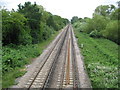
Staines: Windsor branch line railway
The railway was opened here, from Staines to Datchet, in 1848, finally reaching Windsor in 1849, after a little local, but well-heeled, opposition. Third rail electrification came in 1930. If currently planned proposals succeed this trackwork would also form part of the AirTrack railway linking Heathrow Terminal 5 with Staines and main line railway routes to the south-west. This is the view looking towards Staines, taken from the Church Lammas bridge which has always allowed commoners to access Staines Moor. For a view in the opposite direction towards Datchet and Windsor please see Image
Image: © Nigel Cox
Taken: 20 Jun 2010
0.13 miles
10
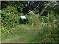
Information board
The information board by the entrance to the footpath to Staines Moor at the rear of the Waters Drive recreation ground.
Image: © Alan Hunt
Taken: 13 Aug 2013
0.13 miles