IMAGES TAKEN NEAR TO
Kotan Drive, STAINES-UPON-THAMES, TW18 4TU
Introduction
This page details the photographs taken nearby to Kotan Drive, TW18 4TU by members of the Geograph project.
The Geograph project started in 2005 with the aim of publishing, organising and preserving representative images for every square kilometre of Great Britain, Ireland and the Isle of Man.

There are currently over 7.5m images from over14,400 individuals and you can help contribute to the project by visiting https://www.geograph.org.uk
Image Map
Images are licensed for reuse under creativecommons.org/licenses/by-sa/2.0
Notes
- Clicking on the map will re-center to the selected point.
- The higher the marker number, the further away the image location is from the centre of the postcode.
Image Listing (74 Images Found)
Images are licensed for reuse under creativecommons.org/licenses/by-sa/2.0
Image
Details
Distance
2
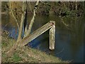
Bollard, River Thames
A disused bollard on the south bank of the Thames at Pooley Green, possibly associated with the nearby water treatment plant.
Image: © Alan Hunt
Taken: 14 Mar 2013
0.06 miles
3

Office window reflections
An office backing on to the Thames path near the M25 bridge over the river.
Image: © Robert Eva
Taken: 5 Jan 2017
0.07 miles
4
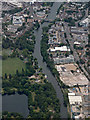
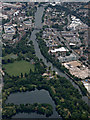
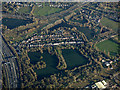
Staines from the air
Looking over Queensmead Lake reservoir, along the River Thames towards the town centre.
Image: © Thomas Nugent
Taken: 3 Aug 2015
0.07 miles
5
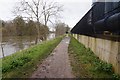
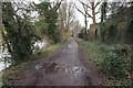
The Thames Path between Staines and Runnymede
Going along the right bank of the river, the M25 motorway crosses the Thames on the bridge ahead.
Image: © Eirian Evans
Taken: 14 Oct 2011
0.07 miles
6
Staines from the air
Looking over Queensmead Lake reservoir, along the River Thames towards the town centre.
Image: © Thomas Nugent
Taken: 3 Aug 2015
0.07 miles
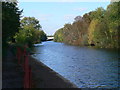
9
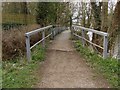
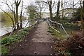
Thames towpath bridge
The iron bridge over the drainage channel which enters the Thames just east of the M25 bridge.
Image: © Alan Hunt
Taken: 12 Mar 2013
0.13 miles
10
Queensmead Lake from the air
Alongside the M25 motorway, the A30 road and the River Thames.
Image: © Thomas Nugent
Taken: 19 Jan 2020
0.13 miles