IMAGES TAKEN NEAR TO
High Street, STAINES-UPON-THAMES, TW18 4QY
Introduction
This page details the photographs taken nearby to High Street, TW18 4QY by members of the Geograph project.
The Geograph project started in 2005 with the aim of publishing, organising and preserving representative images for every square kilometre of Great Britain, Ireland and the Isle of Man.

There are currently over 7.5m images from over14,400 individuals and you can help contribute to the project by visiting https://www.geograph.org.uk
Image Map
Images are licensed for reuse under creativecommons.org/licenses/by-sa/2.0
Notes
- Clicking on the map will re-center to the selected point.
- The higher the marker number, the further away the image location is from the centre of the postcode.
Image Listing (279 Images Found)
Images are licensed for reuse under creativecommons.org/licenses/by-sa/2.0
Image
Details
Distance
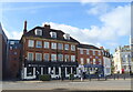
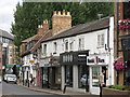
2
Town Hall Square, Staines
The Blue Anchor - a former pub - is in the foreground, and the Town Hall can be seen at the back.
Image: © Ruth Sharville
Taken: 30 May 2010
0.02 miles
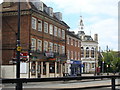
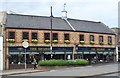
4
Staines - Blue Anchor
Georgian building in central Staines.
Image: © Colin Smith
Taken: 13 Jun 2015
0.02 miles
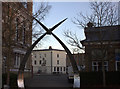
5
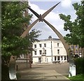
Swan Arch and War Memorial, Staines
This is one of two Swan Arches which mark entrances to the riverside Memorial Gardens. They were hand-made from stainless steel by Anthony & Simon Robinson. The motifs on the legs were designed by pupils of Kingscroft Junior School, each depicting images of the town. Both arches have a single swan in flight at the top – the swan represents the symbol of Staines.
The war memorial sits in the Market Square and is built of Portland Stone. It was unveiled by George Bingham, 5th Earl of Lucan, in 1920. It originally sat in the Memorial Gardens, but was moved here in 2002 as part of the town redevelopment scheme. It is mounted by a winged figure of Victory holding a torch and a wreath.
Image: © Sean Davis
Taken: 28 Jun 2012
0.02 miles
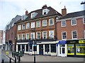
6
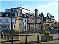
Staines war memorial and Conservative Club
The memorial is a grade II listed building, the club is not.
Image: © Robin Webster
Taken: 17 Jan 2015
0.03 miles
10
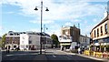
Old Centre of Staines upon Thames
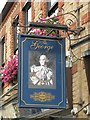
Clarence Street at Staines upon Thames. There is so much history in this photo, going back to Roman times. Clarence Street was built around the same time as the current Staines Bridge (c1832) and has some well-preserved Georgian houses. It is named after Prince William, 1st Duke of Clarence, who visited it on 14th September 1829. He later returned on 23rd April 1832 as William IV with his wife Queen Adelaide, to officially open the new bridge in great ceremony. The Old George Inn (15th century) is on the right as is the entrance to Church Street. On the left is Market Square which led to the older Staines Bridges. To my right, and out of photo, is High Street which was on the line of the old Roman Road through Ad Pontes (meaning by the bridges and the old Roman name for Staines).
I could go on for pages here, but if you wish to read more see https://sites.google.com/site/staineshistoricalwalks/home/staines-history-walk-part-1
Image: © Sean Davis
Taken: 12 Oct 2012
0.03 miles