IMAGES TAKEN NEAR TO
Station Path, STAINES-UPON-THAMES, TW18 4LW
Introduction
This page details the photographs taken nearby to Station Path, TW18 4LW by members of the Geograph project.
The Geograph project started in 2005 with the aim of publishing, organising and preserving representative images for every square kilometre of Great Britain, Ireland and the Isle of Man.

There are currently over 7.5m images from over14,400 individuals and you can help contribute to the project by visiting https://www.geograph.org.uk
Image Map
Images are licensed for reuse under creativecommons.org/licenses/by-sa/2.0
Notes
- Clicking on the map will re-center to the selected point.
- The higher the marker number, the further away the image location is from the centre of the postcode.
Image Listing (126 Images Found)
Images are licensed for reuse under creativecommons.org/licenses/by-sa/2.0
Image
Details
Distance
3
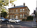
Staines old police station
The new police station can be seen in the distance. (Also on http://www.geograph.org.uk/photo/268082).
Image: © Ray Stanton
Taken: 26 Oct 2006
0.04 miles
5
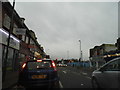
Waiting at the lights, High Street Staines
Image: © David Howard
Taken: 3 Feb 2013
0.06 miles
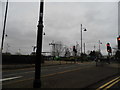
6
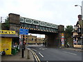
Iron railway bridge in Staines town centre
Image: © Ruth Sharville
Taken: 29 May 2010
0.06 miles
7

Modern development on High Street, Staines
Image: © David Martin
Taken: 30 Jan 2023
0.06 miles
8
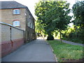
The Oast House from Station Path looking towards the station
Image: © Mumpenny
Taken: 19 Jul 2005
0.07 miles
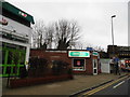
10
South Street, Staines
The car park on the left is in the fork of two railway lines, one to Egham and one to Wraysbury.
Image: © David Howard
Taken: 3 Feb 2013
0.08 miles