IMAGES TAKEN NEAR TO
Greenlands Road, STAINES-UPON-THAMES, TW18 4LR
Introduction
This page details the photographs taken nearby to Greenlands Road, TW18 4LR by members of the Geograph project.
The Geograph project started in 2005 with the aim of publishing, organising and preserving representative images for every square kilometre of Great Britain, Ireland and the Isle of Man.

There are currently over 7.5m images from over14,400 individuals and you can help contribute to the project by visiting https://www.geograph.org.uk
Image Map
Images are licensed for reuse under creativecommons.org/licenses/by-sa/2.0
Notes
- Clicking on the map will re-center to the selected point.
- The higher the marker number, the further away the image location is from the centre of the postcode.
Image Listing (75 Images Found)
Images are licensed for reuse under creativecommons.org/licenses/by-sa/2.0
Image
Details
Distance
1
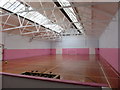
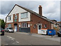
Inside the Leacroft Centre - former Drill Hall
The former drill hall of the 8th Battalion, Middlesex Regiment (H Company) seems to be in very good condition, and well used as a youth centre for all types of activities, although what the old soldiers would make of the loud music that was playing when I was warmly welcomed in, I don't know! See also Image and Image
Image: © John S Turner
Taken: 19 Aug 2014
0.07 miles
2
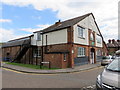
Leacroft Centre, Raleigh Court - former Drill Hall (2)
Looking across Raleigh Court towards the north side of the Leacroft Centre, which was once the drill hall for the 8th Battalion, Middlesex Regiment (H Company) and which first appears on the 1914-15 O.S. map. The building seems to be in good condition and well used as a youth centre, although what the old soldiers would make of the loud music that was playing when I was warmly welcomed in, I don't know! See also Image
Image: © John S Turner
Taken: 19 Aug 2014
0.08 miles
3
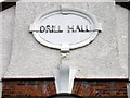
Drill Hall plaque on Leacroft Centre, Raleigh Court
This 'Drill Hall' plaque is high above the main door of the Leacroft Centre, so there is no mistaking the building's original purpose. See also: Image
Image: © John S Turner
Taken: 19 Aug 2014
0.08 miles
4
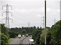
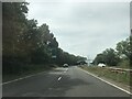
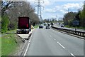
Dual Carriageway near Staines (A308).
A view in the direction of Ashford and Sunbury Cross.
Image: © Anonymous
Taken: 20 Jul 2009
0.09 miles
5
Leacroft Centre, Raleigh Court - former Drill Hall
Looking across Raleigh Court towards the Leacroft Centre, which was once the drill hall for the 8th Battalion, Middlesex Regiment (H Company) and it first appears on the 1914-15 O.S. map. The building seems to be in good condition and well used as a youth centre, although what the old soldiers would make of the loud music that was playing when I was warmly welcomed in, I don't know!
Image: © John S Turner
Taken: 19 Aug 2014
0.09 miles
7
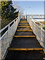
Footbridge over the A308
The bridge crosses the A308 Staines by-pass just east of the Crooked Billet roundabout.
Image: © Stefan Czapski
Taken: 29 Dec 2013
0.10 miles
8
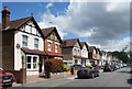
Greenlands Road, Staines
A pleasant area of pre war suburban housing with not really enough room for all the cars.
Quite quiet, with the top end blocked off to vehicles.
Image: © Des Blenkinsopp
Taken: 6 Jun 2019
0.10 miles
9
Layby on the A308 near Staines
The A308 runs between Kensington, in London, and Bisham in Berkshire, staying no more than 3 miles from the River Thames http://en.wikipedia.org/wiki/A308_road .
The short section between the A30, north of Staines Upon Thames, and Ashford is a dual carriageway forming part of the Staines Bypass.
Image: © David Dixon
Taken: 11 Apr 2015
0.11 miles
10
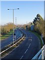
The A308 Staines by-pass
View south-east towards Sunbury and Kingston from a footbridge just east of the Crooked Billet roundabout.
The light might be mistaken for morning light, but this was in fact a Sunday afternoon - the last Sunday of 2013.
Image: © Stefan Czapski
Taken: 29 Dec 2013
0.13 miles