IMAGES TAKEN NEAR TO
George Street, STAINES-UPON-THAMES, TW18 4LB
Introduction
This page details the photographs taken nearby to George Street, TW18 4LB by members of the Geograph project.
The Geograph project started in 2005 with the aim of publishing, organising and preserving representative images for every square kilometre of Great Britain, Ireland and the Isle of Man.

There are currently over 7.5m images from over14,400 individuals and you can help contribute to the project by visiting https://www.geograph.org.uk
Image Map
Images are licensed for reuse under creativecommons.org/licenses/by-sa/2.0
Notes
- Clicking on the map will re-center to the selected point.
- The higher the marker number, the further away the image location is from the centre of the postcode.
Image Listing (116 Images Found)
Images are licensed for reuse under creativecommons.org/licenses/by-sa/2.0
Image
Details
Distance
3
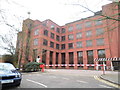
Staines old police station
The new police station can be seen in the distance. (Also on http://www.geograph.org.uk/photo/268082).
Image: © Ray Stanton
Taken: 26 Oct 2006
0.05 miles
4
The Oast House from Station Path looking towards the station
Image: © Mumpenny
Taken: 19 Jul 2005
0.05 miles
5
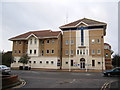
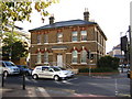
Staines new police station
Staines is/was in Middlesex but is looked after by the Surrey Police. (Picture of the old police station in TQ0371 http://www.geograph.org.uk/photo/268084).
Image: © Ray Stanton
Taken: 26 Oct 2006
0.05 miles
7
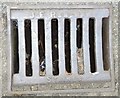
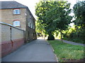
JE Renshaw Drain
This is in Matthews Lane, next to Staines Police Station. John Enoch Renshaw started his Iron Foundry around 1903 at Mill Mead. Now the aptly named the Renshaw Industrial Estate. The foundry closed in the mid-1970s. However, there are still some examples of its street furniture within the town.
Image: © Sean Davis
Taken: 4 Sep 2012
0.05 miles
8
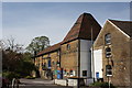
Staines Oast House, Kingston Road, Staines
Image: © Oast House Archive
Taken: 26 Apr 2008
0.06 miles
9
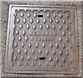
Renshaw Manhole Cover
"Renshaw Staines" manhole cover in Matthews Lane next to Staines Police Station.
John Enoch Renshaw started his Iron Foundry around 1903 at Mill Mead. Now the aptly named the Renshaw Industrial Estate. The foundry closed in the mid-1970s. However, there are still some other examples of its street furniture within the town.
Image: © Sean Davis
Taken: 4 Sep 2012
0.06 miles
10
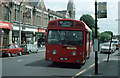
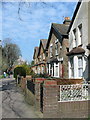
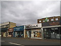
Kingston Road, Staines
Lots of interest in this 1976 view of a number 90 bus arriving from Richmond. The vehicle is an AEC Swift with Marshalls bodywork. Although dual entrance, in 1976 these vehicles had their centre doors sealed and additional seating installed and they were recoded from SM to SMD. They operated the route for only 2 years in this form before being withdrawn and replaced by Leyland Nationals.
The stop is a rare example of a dual logo bus and coach stop and is still mounted on the old cast iron pole rather than the standard concrete stop that was introduced in the 1940's
The shops on the left include a London Co-Operative Society (LCS) store complete with clock. The fronts of the stores here have all been rebuilt along with the roofline. The LCS is now Camberley Auto Factors.
The line of trees behind the bus on the right of the shot still exists, but Staines Methodist Church on the corner of Sidney Road - the spire of which is visible above the bus - has been demolished and replaced with housing. The old church was demolished sometime after 1987 when a new building was erected in Thames Street. Info regarding the church supplied by Ian Sankey.
Image: © Martin Addison
Taken: Unknown
0.06 miles