IMAGES TAKEN NEAR TO
Midway Close, STAINES-UPON-THAMES, TW18 4HW
Introduction
This page details the photographs taken nearby to Midway Close, TW18 4HW by members of the Geograph project.
The Geograph project started in 2005 with the aim of publishing, organising and preserving representative images for every square kilometre of Great Britain, Ireland and the Isle of Man.

There are currently over 7.5m images from over14,400 individuals and you can help contribute to the project by visiting https://www.geograph.org.uk
Image Map
Images are licensed for reuse under creativecommons.org/licenses/by-sa/2.0
Notes
- Clicking on the map will re-center to the selected point.
- The higher the marker number, the further away the image location is from the centre of the postcode.
Image Listing (35 Images Found)
Images are licensed for reuse under creativecommons.org/licenses/by-sa/2.0
Image
Details
Distance
1
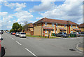
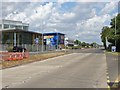
Midway Close, Staines
Off Stanwell New Road, now a no through road after realignment of the A3044.
Image: © Des Blenkinsopp
Taken: 6 Jun 2019
0.01 miles
2
Midway Close
A short cul-de-sac off Stanwell New Road, possibly named as it is about half way along that road. The embankment of the Staines reservoir can be seen in the background.
Image: © Alan Hunt
Taken: 29 Jul 2013
0.01 miles
3
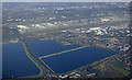
Staines reservoirs from the air
Heathrow Airport is in the background.
Image: © Thomas Nugent
Taken: 19 Jan 2020
0.04 miles
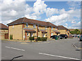
4
Stanwell New Road
Modern housing at the northern end of Stanwell New Road.
Image: © Alan Hunt
Taken: 29 Jul 2013
0.05 miles
5
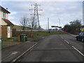
Stanwell New Road
Stanwell New Road with the pylons heading up the A3044
Image: © Shaun Ferguson
Taken: 15 Feb 2013
0.07 miles
6
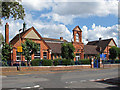
Shortwood County Infant School
in Stanwell New Road (formerly Stanwell Moor Road). Built in 1900. Yes, I meant to get the pylon in the background. Note that the lines which have come from Image go down at this point into a sub-station.
Image: © Roger W Haworth
Taken: 14 Mar 2006
0.07 miles
7
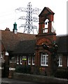
Shortwood infant school
Shortwood infant school was originally built as a Church of England infant school in 1890 by Sir John Gibbons to serve Stanwell. It was transferred to Staines in 1896 and enlarged in 1900, that date being reflected by the terracotta plaque on the bell tower.
Image: © Alan Hunt
Taken: 29 Jul 2013
0.08 miles
8
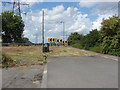
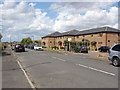
The end of the road
The northern end of Stanwell New Road where it is cut off by Stanwell Moor Road.
Image: © Alan Hunt
Taken: 29 Jul 2013
0.09 miles
9
A30, London Road
The A30, London road just east of the Crooked Billet Roundabout. The storage depot on the north side of the road is a recent addition having replaced older industrial units that were on that site.
Image: © Alan Hunt
Taken: 29 Jul 2013
0.14 miles
10
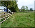
The edge of Shortwood Common
Animals have been grazed here for centuries and in 1794 a man was sentenced to whipping for stealing Mr Watson's geese from Shortwood Common. In the past parts of Shortwood Common have been a golf course and a Victorian rubbish tip. Shortwood Pond, which is ahead in the trees to the left, was probably dug as a gravel pit in the early to mid 19th century.
In this photograph London Road (A30) is on the left. This was a Roman road.
Image: © Marathon
Taken: 10 Sep 2014
0.15 miles