IMAGES TAKEN NEAR TO
Birch Green, STAINES-UPON-THAMES, TW18 4HA
Introduction
This page details the photographs taken nearby to Birch Green, TW18 4HA by members of the Geograph project.
The Geograph project started in 2005 with the aim of publishing, organising and preserving representative images for every square kilometre of Great Britain, Ireland and the Isle of Man.

There are currently over 7.5m images from over14,400 individuals and you can help contribute to the project by visiting https://www.geograph.org.uk
Image Map
Images are licensed for reuse under creativecommons.org/licenses/by-sa/2.0
Notes
- Clicking on the map will re-center to the selected point.
- The higher the marker number, the further away the image location is from the centre of the postcode.
Image Listing (55 Images Found)
Images are licensed for reuse under creativecommons.org/licenses/by-sa/2.0
Image
Details
Distance
1
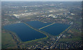
Staines reservoirs from the air
With Staines in the foreground and Stanwell and Heathrow Airport beyond the reservoirs.
Image: © Thomas Nugent
Taken: 19 Jan 2020
0.04 miles
2

Waterworks
Pumping Station south of George VI Reservoir
Image: © Ray Stanton
Taken: 26 Oct 2006
0.04 miles
3
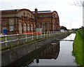
Staines Pumping Station and Aqueduct
Staines Pump House was built c1886 to pump water from the Staines Reservoir Aqueduct into the reservoirs just north of here.
Image: © Sean Davis
Taken: 13 Nov 2012
0.08 miles
4
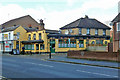
The Three Tuns, Staines
On London Road.
Image: © Robin Webster
Taken: 17 Jan 2015
0.09 miles
5
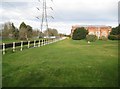
Staines Reservoirs Aqueduct
The Aqueduct runs beyond the white railings in this view taken from the Crooked Billet roundabout. On the right, although actually in Image, is the Grade II Listed Reservoirs Engine House built in 1896.
Image: © Nigel Cox
Taken: 23 Mar 2014
0.10 miles
6
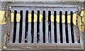
Drain Cover
This is one of three Renshaw drain covers in News Street. John Enoch Renshaw started his Iron Foundry around 1903 at Mill Mead. Now the aptly named the Renshaw Industrial Estate. The foundry closed in the mid-1970s. However, there are still some other examples of its street furniture within the town.
Image: © Sean Davis
Taken: 24 Aug 2012
0.11 miles
7
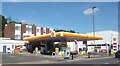
Shell Petrol Station
This Shell Petrol Station, on London Road, Staines has been here for many years as you can see from https://www.geograph.org.uk/photo/1781714
Image: © Sean Davis
Taken: 4 Sep 2012
0.11 miles
8
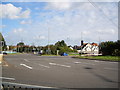
Crooked Billet Roundabout
where the A30, A308 and A3044 meet. Includes traffic lights and a road running through the middle so A30 traffic does not have to travel round the edge!
Image: © Ray Stanton
Taken: 26 Oct 2006
0.11 miles
9
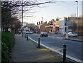
London Road, Staines - view towards the town centre
Worth comparing with Martin Addison's 1976 contribution Image which was taken from about the same spot (near the corner of Greenlands Road) and with similar orientation.
Shot taken at about 2.20pm on December 29th, 2013. For the record, the price of unleaded petrol at the Shell garage was 129.9p per litre.
Image: © Stefan Czapski
Taken: 29 Dec 2013
0.12 miles
10
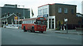
London Road
A view of London Road (A308) as it was in 1976. Very little has changed building wise - the white fencing around the service station forecourt appears to have gone and the associated vehicle maintenance facility appears to have changed name. The dual carriageway sign has gone though.
The bus on the 216 is RF449 an AEC Regal. It is in its last few months of service from Kingston garage and was withdrawn in October 1976. It saw subsequent use in a non-psv role until being scrapped in 1985. Information from Ian's Bus Stop at http://www.countrybus.org/rf/RF4a.htm
Image: © Martin Addison
Taken: Unknown
0.12 miles