IMAGES TAKEN NEAR TO
Church Street, STAINES-UPON-THAMES, TW18 4EP
Introduction
This page details the photographs taken nearby to Church Street, TW18 4EP by members of the Geograph project.
The Geograph project started in 2005 with the aim of publishing, organising and preserving representative images for every square kilometre of Great Britain, Ireland and the Isle of Man.

There are currently over 7.5m images from over14,400 individuals and you can help contribute to the project by visiting https://www.geograph.org.uk
Image Map
Images are licensed for reuse under creativecommons.org/licenses/by-sa/2.0
Notes
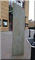
- Clicking on the map will re-center to the selected point.
- The higher the marker number, the further away the image location is from the centre of the postcode.
Image Listing (283 Images Found)
Images are licensed for reuse under creativecommons.org/licenses/by-sa/2.0
Image
Details
Distance
1
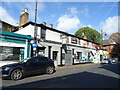
The London Stone, Staines
On Church Street.
See Image] for sign.
Image: © JThomas
Taken: 27 May 2022
0.01 miles
2
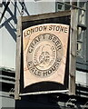
Sign for the London Stone, Staines
See Image] for context.
Image: © JThomas
Taken: 27 May 2022
0.01 miles
3
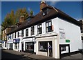
Blowers The Barbers of Church Street
This old row of buildings on Church Street date from the late 17th century. All are Grade II listed. The ground floors have been converted to shops, but the upper floors and roofs have been kept almost original. As for Blowers The Barbers it still sides onto Gorings's Square, but has blown to the right and now one door up.
Image: © Sean Davis
Taken: 12 Oct 2012
0.01 miles
4
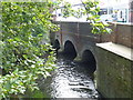
Church Street Bridge over River Colne
The old Church Street Bridge over River Colne taken from the footbridge from Church Street to Two Rivers Shopping Centre.
Image: © Sean Davis
Taken: 17 Sep 2012
0.02 miles
5
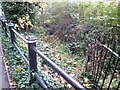
Sweeps Ditch at Staines
Just east of the footbridge which joins Two Rivers Shopping Centre to Church Street, and where the Colne and Wraysbury rivers meet is a small section of a dried up water channel. This was from where the River Colne originally fed Sweeps Ditch.
Sweeps Ditch was an ancient man-made mill stream or defence ditch which flowed through Staines. In Roman & Medieval Times it formed the western and northern boundary of Town Island (sometimes referred to as High Street Island). However, with the building of the Elmsleigh Shopping Centre and the redevelopment of the town centre in the 1970s, the water source was cut. A new water source was provided by Thames Water in 1982, when it installed a pump house in the Riverside car park and this takes water from the Thames. However, the stream no longer goes through the centre of the town, instead it goes underground in a pipe across Thames Street and South Street and re-emerges to the south-east of the town centre, before flowing east and south to rejoin the Thames over a mile downstream near Penton Hook Lock.
Image: © Sean Davis
Taken: 6 Nov 2012
0.03 miles
7
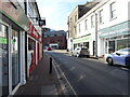
Row on Clarence Street, Staines
The end slightly set back building is boarded up.
Image: © Robin Webster
Taken: 17 Jan 2015
0.04 miles
8
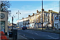
Old Centre of Staines upon Thames
Clarence Street at Staines upon Thames. There is so much history in this photo, going back to Roman times. Clarence Street was built around the same time as the current Staines Bridge (c1832) and has some well-preserved Georgian houses. It is named after Prince William, 1st Duke of Clarence, who visited it on 14th September 1829. He later returned on 23rd April 1832 as William IV with his wife Queen Adelaide, to officially open the new bridge in great ceremony. The Old George Inn (15th century) is on the right as is the entrance to Church Street. On the left is Market Square which led to the older Staines Bridges. To my right, and out of photo, is High Street which was on the line of the old Roman Road through Ad Pontes (meaning by the bridges and the old Roman name for Staines).
I could go on for pages here, but if you wish to read more see https://sites.google.com/site/staineshistoricalwalks/home/staines-history-walk-part-1
Image: © Sean Davis
Taken: 12 Oct 2012
0.04 miles
9
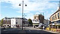
Sweeps Ditch Stone
The Sweeps Ditch Stone is outside the entrance to VUE Cinema. The stone and 15 round plaques, found on the ground throughout the Two Rivers car park, indicate the original route of Sweeps Ditch.
Sweeps Ditch is an ancient man-made mill stream which flowed through Staines. In Roman & Medieval Times it formed the western and northern boundary of Town Island (sometimes referred to as High Street Island).
Image: © Sean Davis
Taken: 14 Sep 2012
0.05 miles
10
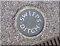
Sweeps Ditch Disc at Two Rivers Car Park
The Sweeps Ditch Stone outside the entrance to VUE Cinema and 15 of these round discs on the ground throughout the Two Rivers car park, indicate the original route of Sweeps Ditch.
Sweeps Ditch is an ancient man-made mill stream which flowed through Staines. In Roman & Medieval Times it formed the western and northern boundary of Town Island (sometimes referred to as High Street Island).
Image: © Sean Davis
Taken: 14 Sep 2012
0.05 miles