IMAGES TAKEN NEAR TO
High Street, STAINES-UPON-THAMES, TW18 4AH
Introduction
This page details the photographs taken nearby to High Street, TW18 4AH by members of the Geograph project.
The Geograph project started in 2005 with the aim of publishing, organising and preserving representative images for every square kilometre of Great Britain, Ireland and the Isle of Man.

There are currently over 7.5m images from over14,400 individuals and you can help contribute to the project by visiting https://www.geograph.org.uk
Image Map
Images are licensed for reuse under creativecommons.org/licenses/by-sa/2.0
Notes
- Clicking on the map will re-center to the selected point.
- The higher the marker number, the further away the image location is from the centre of the postcode.
Image Listing (77 Images Found)
Images are licensed for reuse under creativecommons.org/licenses/by-sa/2.0
Image
Details
Distance
1
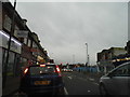
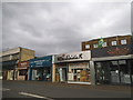
Waiting at the lights, High Street Staines
Image: © David Howard
Taken: 3 Feb 2013
0.02 miles
2

Offices on High Street, Staines
From the end of Kingston Road
Image: © David Howard
Taken: 18 Jan 2015
0.03 miles
3

Modern development on High Street, Staines
Image: © David Martin
Taken: 30 Jan 2023
0.03 miles
4
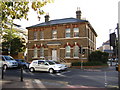
Staines old police station
The new police station can be seen in the distance. (Also on http://www.geograph.org.uk/photo/268082).
Image: © Ray Stanton
Taken: 26 Oct 2006
0.04 miles
6
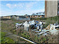
Rubbish on vacant site, Fairfield Avenue, Staines
Now built on - the site, not the rubbish.
Image: © Robin Webster
Taken: 17 Jan 2015
0.05 miles
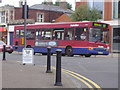
8
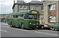
Green Line Through Staines
A London Country bus on the south London orbital 725 route between Gravesend and Windsor via Swanscombe, Northfleet, Dartford, Crayford, Bexley, Sidcup, Chislehurst, Bromley, Beckenham, Addiscombe, Croydon, Wallington, Sutton, North Cheam, New Malden, Worcester Park, Kingston, Hampton Court, Sunbury, Ashford, Staines, Egham and Englefield Green. RF221 - an AEC Regal, deputising for an AEC Swift that would normally be operating on this route in 1976 - is on the eastbound run, on Kingston Road.
Behind the bus was Staines police station - recently replaced by a new building further along Kingston Road. The ironwork on the roof carried the air raid siren. The front of the old police station can be seen in Image by Ray Stanton. The old station and the building to the right of the bus appear to have been converted into offices.
The traffic lights behind the bus are at the junction with London Road / High Street. The parade of shops opposite the junction have been demolished and replaced with an office block.
Image: © Martin Addison
Taken: Unknown
0.05 miles
9
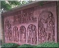
Roman Frieze on London Road
This Roman Frieze on London Road is just next to the Old Police Station. London Road is on the route of the old Roman Road from London to Silchester. It depicts the Roman era in Staines, when the town was known as Ad Pontes (by the bridges). An inscription on the sculptor states:
“This panel is based on a Samian pot in the style of the potter “Cornutus” AD 125 found on this site”
Other inscriptions on the frieze are AD Pontes AD XLV, Giorgio Fanelli Facit MMII, Hadrian’s Wall CXXII. So I suppose these represent AD Pontes AD 45, Giorgio Fanelli Facit 2002 (possibly maker and date), Hadrian’s Wall 122 (the building of the wall began in AD 122).
Image: © Sean Davis
Taken: 28 Jun 2012
0.06 miles
10
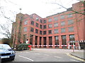
Office block on George Street, Staines
Image: © David Howard
Taken: 3 Feb 2013
0.06 miles