IMAGES TAKEN NEAR TO
Mayfield Gardens, STAINES-UPON-THAMES, TW18 3LG
Introduction
This page details the photographs taken nearby to Mayfield Gardens, TW18 3LG by members of the Geograph project.
The Geograph project started in 2005 with the aim of publishing, organising and preserving representative images for every square kilometre of Great Britain, Ireland and the Isle of Man.

There are currently over 7.5m images from over14,400 individuals and you can help contribute to the project by visiting https://www.geograph.org.uk
Image Map
Images are licensed for reuse under creativecommons.org/licenses/by-sa/2.0
Notes
- Clicking on the map will re-center to the selected point.
- The higher the marker number, the further away the image location is from the centre of the postcode.
Image Listing (26 Images Found)
Images are licensed for reuse under creativecommons.org/licenses/by-sa/2.0
Image
Details
Distance
1
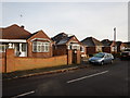
Staines - Bungalows in Mayfield Gardens
Image: © James Emmans
Taken: 3 Jan 2017
0.03 miles
2
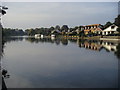
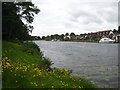
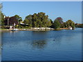
River Thames
River Thames looking to riverside houses on Bundy's Way and Mayfield Gardens
Image: © Shaun Ferguson
Taken: 9 Oct 2012
0.05 miles
3
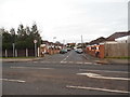
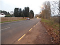
Chertsey Lane at the junction of Mayfield Gardens
Image: © David Howard
Taken: 14 Dec 2014
0.06 miles
4
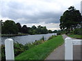
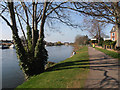
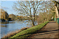
Tow path towards Staines
Looking North up the river Thames just below Staines
Image: © steve
Taken: 14 Aug 2005
0.06 miles
10
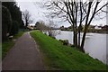
River Thames near Staines
A view along the Thames looking towards Staines. The spire of St Peter's church can be seen on the right.
Image: © Alan Hunt
Taken: 4 Oct 2012
0.11 miles