IMAGES TAKEN NEAR TO
Thorpe Road, STAINES-UPON-THAMES, TW18 3HP
Introduction
This page details the photographs taken nearby to Thorpe Road, TW18 3HP by members of the Geograph project.
The Geograph project started in 2005 with the aim of publishing, organising and preserving representative images for every square kilometre of Great Britain, Ireland and the Isle of Man.

There are currently over 7.5m images from over14,400 individuals and you can help contribute to the project by visiting https://www.geograph.org.uk
Image Map
Images are licensed for reuse under creativecommons.org/licenses/by-sa/2.0
Notes
- Clicking on the map will re-center to the selected point.
- The higher the marker number, the further away the image location is from the centre of the postcode.
Image Listing (153 Images Found)
Images are licensed for reuse under creativecommons.org/licenses/by-sa/2.0
Image
Details
Distance
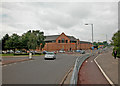
2
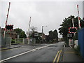
Egham Hythe: Thorpe Road level crossing
Even though it was a very wet day this view of the level crossing is surprisingly devoid of traffic and pedestrians.
Image: © Nigel Cox
Taken: 5 Aug 2008
0.04 miles
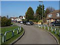
3
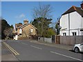
Goring Road
The junction of Goring Road with Thorpe Road.
Image: © Alan Hunt
Taken: 14 Mar 2013
0.07 miles
4

Chertsey Lane business park
The office blocks of the business park off Chertsey Lane.
Image: © Alan Hunt
Taken: 14 Mar 2013
0.09 miles
5
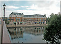
View from the bridge
Riverside apartments.
Image: © Dennis Turner
Taken: 5 Sep 2005
0.09 miles
7
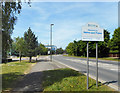
Welcome to Staines-upon-Thames
Staines has only been officially "Upon Thames" since 2012.
Various towns have had that suffix for years, usually because there is another town with the same name elsewhere in the country; Kingston, Richmond, Henley, Goring etc....but this article http://www.bbc.co.uk/news/uk-england-surrey-18118309 suggests that the council thought it would just be an image booster after Staines got a lot of flack on the Ali G show.
Image: © Des Blenkinsopp
Taken: 10 May 2017
0.12 miles
9
Goring Road, Staines
The short connecting road between Wapshott Road and Goring Road.
Image: © Alan Hunt
Taken: 14 Mar 2013
0.13 miles
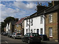
10
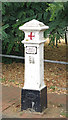
Coal tax boundary post no.86, The Hythe
The location of this post is shown in Image and Image See also Image
There were originally nearly 280 coal tax posts located around London, of which about 210 are still extant; around 180 of these (85%) are 3 ft high white-painted square bollards with a pyramidal top, decorative raised bands, and the shield from the City of London’s arms, like this one. Photos of the coal tax posts on Geograph are at http://www.geograph.org.uk/search.php?i=86542993&page=1 .
The posts were erected under the Coal and Wine Duties (Continuation) Act of 1861 to mark the points at which duty had to be paid on coal being transported to London. The boundary was set at that of the Metropolitan Police District, and the resulting revenue was used by the Corporation of the City of London to fund public works. For further info see http://www.coaldutyposts.org.uk/cityposts.html .
This coal tax post is Grade II listed https://historicengland.org.uk/listing/the-list/list-entry/1378033 .
Image: © Mike Quinn
Taken: 8 Aug 2018
0.13 miles