IMAGES TAKEN NEAR TO
Rochester Road, STAINES-UPON-THAMES, TW18 3HN
Introduction
This page details the photographs taken nearby to Rochester Road, TW18 3HN by members of the Geograph project.
The Geograph project started in 2005 with the aim of publishing, organising and preserving representative images for every square kilometre of Great Britain, Ireland and the Isle of Man.

There are currently over 7.5m images from over14,400 individuals and you can help contribute to the project by visiting https://www.geograph.org.uk
Image Map
Images are licensed for reuse under creativecommons.org/licenses/by-sa/2.0
Notes
- Clicking on the map will re-center to the selected point.
- The higher the marker number, the further away the image location is from the centre of the postcode.
Image Listing (23 Images Found)
Images are licensed for reuse under creativecommons.org/licenses/by-sa/2.0
Image
Details
Distance
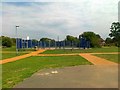
4
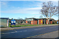
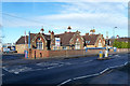
The Hythe Centre
On Thorpe Road, opened in 2002.
Image: © Robin Webster
Taken: 17 Jan 2015
0.14 miles
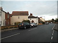
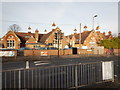
8
Hythe Centre
A new social centre / public hall on Thorpe Road.
Image: © David Squire
Taken: 21 Apr 2006
0.15 miles
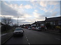
9
Hythe Community Primary School
So the white sign says, but on the wall it says 'Springtime Nursery'.
Image: © Robin Webster
Taken: 17 Jan 2015
0.16 miles
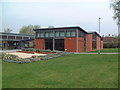
10
Springtime Nursery School on Thorpe Road
The School building on the right has been converted to flats with an access road called Old School Mews.
Image: © James Emmans
Taken: 3 Jan 2017
0.16 miles