IMAGES TAKEN NEAR TO
Wapshott Road, STAINES-UPON-THAMES, TW18 3HB
Introduction
This page details the photographs taken nearby to Wapshott Road, TW18 3HB by members of the Geograph project.
The Geograph project started in 2005 with the aim of publishing, organising and preserving representative images for every square kilometre of Great Britain, Ireland and the Isle of Man.

There are currently over 7.5m images from over14,400 individuals and you can help contribute to the project by visiting https://www.geograph.org.uk
Image Map
Images are licensed for reuse under creativecommons.org/licenses/by-sa/2.0
Notes
- Clicking on the map will re-center to the selected point.
- The higher the marker number, the further away the image location is from the centre of the postcode.
Image Listing (67 Images Found)
Images are licensed for reuse under creativecommons.org/licenses/by-sa/2.0
Image
Details
Distance
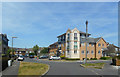
1
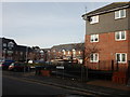
Egham Hythe - Modern Flats in Wapshott Road
Image: © James Emmans
Taken: 3 Jan 2017
0.01 miles
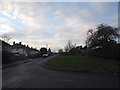
2
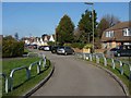
Goring Road, Staines
The short connecting road between Wapshott Road and Goring Road.
Image: © Alan Hunt
Taken: 14 Mar 2013
0.03 miles
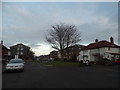
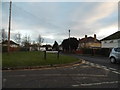
3
Wapshott Road, Staines
One of the road sering the housing estates off Chertsey Lane.
Image: © Alan Hunt
Taken: 14 Mar 2013
0.06 miles
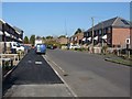
4
Bowes Road, Egham Hythe
A mixture of mid 20th and early 21st century residential development.
Image: © Des Blenkinsopp
Taken: 10 May 2017
0.08 miles
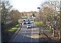
6

Chertsey Lane business park
The office blocks of the business park off Chertsey Lane.
Image: © Alan Hunt
Taken: 14 Mar 2013
0.10 miles