IMAGES TAKEN NEAR TO
River Park Avenue, STAINES-UPON-THAMES, TW18 3FA
Introduction
This page details the photographs taken nearby to River Park Avenue, TW18 3FA by members of the Geograph project.
The Geograph project started in 2005 with the aim of publishing, organising and preserving representative images for every square kilometre of Great Britain, Ireland and the Isle of Man.

There are currently over 7.5m images from over14,400 individuals and you can help contribute to the project by visiting https://www.geograph.org.uk
Image Map
Images are licensed for reuse under creativecommons.org/licenses/by-sa/2.0
Notes
- Clicking on the map will re-center to the selected point.
- The higher the marker number, the further away the image location is from the centre of the postcode.
Image Listing (82 Images Found)
Images are licensed for reuse under creativecommons.org/licenses/by-sa/2.0
Image
Details
Distance
1

Refreshments Kiosk at Homebase, Staines-upon-Thames
The refreshments kiosk in the car park of Homebase, River Park Avenue, Staines-upon-Thames.
This is just a short walk from the Thames Path National Trail and the route of the London Green Belt Way.
Image: © Sean Davis
Taken: 14 Aug 2012
0.04 miles
2
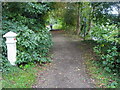
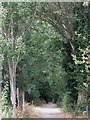
Thames Path
Thames Path by a coal post near River Park Avenue
Image: © Shaun Ferguson
Taken: 3 Oct 2012
0.05 miles
3
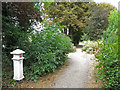
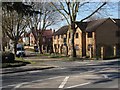
River Park Avenue
The short road that runs from The Causeway to the Thames towpath.
Image: © Alan Hunt
Taken: 14 Mar 2013
0.05 miles
4
The Thames Path leaving Staines
Going upstream on the true right (i.e. south) bank of the river.
Image: © David Purchase
Taken: 28 Apr 2013
0.05 miles
5
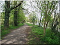
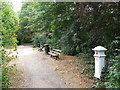
Path by the River Thames near River Park Avenue
Shows the location of Image
Image: © Mike Quinn
Taken: 8 Aug 2018
0.06 miles
6
Path by the River Thames west of River Park Avenue
Image: © Mike Quinn
Taken: 8 Aug 2018
0.07 miles
7
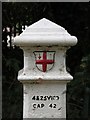
Coal tax boundary post no.84, by River Park Avenue (detail)
See Image and Image Here, the outline of the rectangular correction plate around the original inscription can be clearly seen.
Image: © Mike Quinn
Taken: 8 Aug 2018
0.07 miles
8
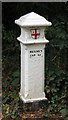
Coal tax boundary post no.84, by River Park Avenue
The location of this post is shown in Image and Image See also Image
There were originally nearly 280 coal tax posts located around London, of which about 210 are still extant; around 180 of these (85%) are 3 ft high white-painted square bollards with a pyramidal top, decorative raised bands, and the shield from the City of London’s arms, like this one. Photos of the coal tax posts on Geograph are at http://www.geograph.org.uk/search.php?i=86542993&page=1 .
The posts were erected under the Coal and Wine Duties (Continuation) Act of 1861 to mark the points at which duty had to be paid on coal being transported to London. The boundary was set at that of the Metropolitan Police District, and the resulting revenue was used by the Corporation of the City of London to fund public works. For further info see http://www.coaldutyposts.org.uk/cityposts.html .
This coal tax post is Grade II listed https://historicengland.org.uk/listing/the-list/list-entry/1028955 .
Image: © Mike Quinn
Taken: 8 Aug 2018
0.07 miles
9
Path by the River Thames near River Park Avenue (2)
Shows the location of Image
Image: © Mike Quinn
Taken: 8 Aug 2018
0.08 miles
10
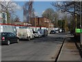
Avenue Road, Staines
The residential road off the Causeway to the west of Staines.
Image: © Alan Hunt
Taken: 14 Mar 2013
0.08 miles