IMAGES TAKEN NEAR TO
Staines Road, STAINES-UPON-THAMES, TW18 2SQ
Introduction
This page details the photographs taken nearby to Staines Road, TW18 2SQ by members of the Geograph project.
The Geograph project started in 2005 with the aim of publishing, organising and preserving representative images for every square kilometre of Great Britain, Ireland and the Isle of Man.

There are currently over 7.5m images from over14,400 individuals and you can help contribute to the project by visiting https://www.geograph.org.uk
Image Map
Images are licensed for reuse under creativecommons.org/licenses/by-sa/2.0
Notes
- Clicking on the map will re-center to the selected point.
- The higher the marker number, the further away the image location is from the centre of the postcode.
Image Listing (48 Images Found)
Images are licensed for reuse under creativecommons.org/licenses/by-sa/2.0
Image
Details
Distance

5

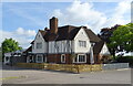
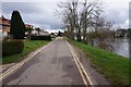
Retreat to the Left
The Retreat is a pub at the junction of Worple Road and Staines Road.
Image: © Des Blenkinsopp
Taken: 10 May 2017
0.14 miles
6
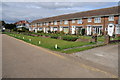
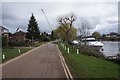
Houses near Penton Hook
Houses probably from the early 1970s overlooking the River Thames near Penton Hook.
Image: © Philip Halling
Taken: 29 Aug 2011
0.16 miles
8
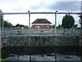
Sluice gates for the Queen Mary reservoir
This is on the Thames near Laleham and is where the water is extracted from the Thames and pumped up to the Queen Mary reservoir
Image: © steve
Taken: 14 Aug 2005
0.16 miles
9
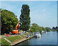
Working on the River Bank
A small watercourse, Sweep's Ditch, joins the Thames here. Work is going on here to install a new penstock at the confluence to prevent river water backing up along the ditch and flooding the area behind. Sweep's Ditch will be pumped into the river while high levels persist.
Image: © Des Blenkinsopp
Taken: 10 May 2017
0.19 miles