IMAGES TAKEN NEAR TO
Garrick Close, STAINES-UPON-THAMES, TW18 2PQ
Introduction
This page details the photographs taken nearby to Garrick Close, TW18 2PQ by members of the Geograph project.
The Geograph project started in 2005 with the aim of publishing, organising and preserving representative images for every square kilometre of Great Britain, Ireland and the Isle of Man.

There are currently over 7.5m images from over14,400 individuals and you can help contribute to the project by visiting https://www.geograph.org.uk
Image Map
Images are licensed for reuse under creativecommons.org/licenses/by-sa/2.0
Notes
- Clicking on the map will re-center to the selected point.
- The higher the marker number, the further away the image location is from the centre of the postcode.
Image Listing (20 Images Found)
Images are licensed for reuse under creativecommons.org/licenses/by-sa/2.0
Image
Details
Distance
1
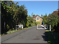
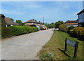
Penton Hook Road
A private residential road that runs from Wheatsheaf Lane to the River Thames towpath.
Image: © Alan Hunt
Taken: 4 Oct 2012
0.02 miles
2
Penton Hook Road
The gates across this private road barring vehicular access from Wheatsheaf Lane, principally used when Staines Town Football Club, whose ground is very close, is playing at home.
Image: © Alan Hunt
Taken: 4 Oct 2012
0.06 miles
3
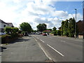
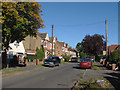
Wheatsheaf Lane
At the junction with Penton Hook Road. Most of this square is 20th century residential streets.
Image: © Des Blenkinsopp
Taken: 10 May 2017
0.09 miles
4
St Pinnock Avenue
Saint Pinnock, or Winnoc, was a seventh century Welsh saint who became an Abbot in Flanders.
He is the patron saint of millers.
More about him on https://en.wikipedia.org/wiki/Winnoc
His connection with a no through road near Staines is unclear.
I took this picture because I'm aware there is a Geograph Gallery called Lesser Saints which is dedicated to not very famous Holy People. Is Pinnock a contender?
Image: © Des Blenkinsopp
Taken: 10 May 2017
0.11 miles
5
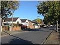
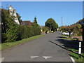
Avondale Avenue, Staines
The view along this residential road in the Knowle Green area of Staines.
Image: © Alan Hunt
Taken: 4 Oct 2012
0.15 miles
6
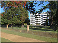
Penton Hall
An apartment block on the banks of the Thames near Penton Hook.
Image: © Alan Hunt
Taken: 4 Oct 2012
0.17 miles
7
Penton Avenue, Staines
The residential road that runs from Wheatsheaf Lane and ends on the towpath of the River Thames.
Image: © Alan Hunt
Taken: 4 Oct 2012
0.19 miles
8
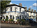
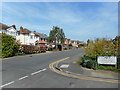
The Wheatsheaf and Pigeon
Situated at the junction between Penton Road and Wheatsheaf Lane, this pub is known locally as the Wee and Pee!
The cottages to the right of the pub are in Wheatsheaf Lane.
Image: © Ruth Sharville
Taken: 8 Oct 2008
0.19 miles
9
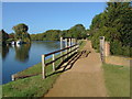
Footbridge, Thames towpath
The footbridge over a drain that runs into the Thames above Penton Hook Lock.
Image: © Alan Hunt
Taken: 4 Oct 2012
0.20 miles