IMAGES TAKEN NEAR TO
Avondale Avenue, STAINES-UPON-THAMES, TW18 2PN
Introduction
This page details the photographs taken nearby to Avondale Avenue, TW18 2PN by members of the Geograph project.
The Geograph project started in 2005 with the aim of publishing, organising and preserving representative images for every square kilometre of Great Britain, Ireland and the Isle of Man.

There are currently over 7.5m images from over14,400 individuals and you can help contribute to the project by visiting https://www.geograph.org.uk
Image Map
Images are licensed for reuse under creativecommons.org/licenses/by-sa/2.0
Notes
- Clicking on the map will re-center to the selected point.
- The higher the marker number, the further away the image location is from the centre of the postcode.
Image Listing (28 Images Found)
Images are licensed for reuse under creativecommons.org/licenses/by-sa/2.0
Image
Details
Distance
1
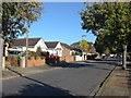
Avondale Avenue, Staines
The view along this residential road in the Knowle Green area of Staines.
Image: © Alan Hunt
Taken: 4 Oct 2012
0.05 miles
2
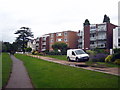
Riverside apartments at Knowle Green
Downstream from Staines.
Image: © Rod Allday
Taken: 22 Jun 2011
0.13 miles
3
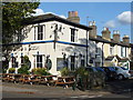
The Wheatsheaf and Pigeon
Situated at the junction between Penton Road and Wheatsheaf Lane, this pub is known locally as the Wee and Pee!
The cottages to the right of the pub are in Wheatsheaf Lane.
Image: © Ruth Sharville
Taken: 8 Oct 2008
0.13 miles
4
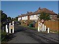
Wheatsheaf Lane
The "river" end of Wheatsheaf Lane at the point that it becomes a private road for residents only, a necessity because everyone would be parking to get to the river towpath.
Image: © Alan Hunt
Taken: 4 Oct 2012
0.13 miles
5
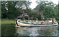
Staines riverbank
Entrance to one of the many modern blocks of apartments south of Staines town centre. Heading upstream is a replica Dutch barge, Vrouwe Johanna (Mrs Johanna).
Image: © Graham Horn
Taken: 24 Aug 2008
0.14 miles
6
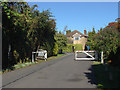
Penton Hook Road
The gates across this private road barring vehicular access from Wheatsheaf Lane, principally used when Staines Town Football Club, whose ground is very close, is playing at home.
Image: © Alan Hunt
Taken: 4 Oct 2012
0.15 miles
7
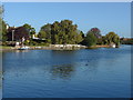
River Thames near Staines
A view along the Thames looking towards Staines. The spire of St Peter's church can be seen on the right.
Image: © Alan Hunt
Taken: 4 Oct 2012
0.16 miles
8
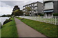
Apartments overlooking the Thames
Apartments overlooking the River Thames near Staines.
Image: © Philip Halling
Taken: 29 Aug 2011
0.17 miles
9
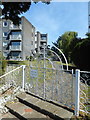
Gate to Glen Court
Access for residents onto the Thames Path.
Image: © Des Blenkinsopp
Taken: 10 May 2017
0.17 miles
10
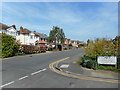
Wheatsheaf Lane
At the junction with Penton Hook Road. Most of this square is 20th century residential streets.
Image: © Des Blenkinsopp
Taken: 10 May 2017
0.17 miles