IMAGES TAKEN NEAR TO
Gresham Road, STAINES-UPON-THAMES, TW18 2BZ
Introduction
This page details the photographs taken nearby to Gresham Road, TW18 2BZ by members of the Geograph project.
The Geograph project started in 2005 with the aim of publishing, organising and preserving representative images for every square kilometre of Great Britain, Ireland and the Isle of Man.

There are currently over 7.5m images from over14,400 individuals and you can help contribute to the project by visiting https://www.geograph.org.uk
Image Map
Images are licensed for reuse under creativecommons.org/licenses/by-sa/2.0
Notes
- Clicking on the map will re-center to the selected point.
- The higher the marker number, the further away the image location is from the centre of the postcode.
Image Listing (70 Images Found)
Images are licensed for reuse under creativecommons.org/licenses/by-sa/2.0
Image
Details
Distance
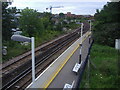
1
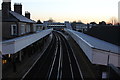
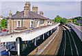
Staines station looking east
Taken from the footbridge at the western end of the station
Image: © Robert Eva
Taken: 5 Jan 2017
0.03 miles
3
Staines Station, looking east from charter train
Image: © Roger Templeman
Taken: 7 Feb 2015
0.03 miles
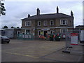
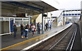
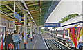
8
Staines Station
Footbridge at Staines Station.
Image: © Philip Halling
Taken: 29 Aug 2011
0.03 miles
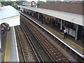
9
Staines station, eastward 2005
View from the footbridge, towards Richmond and London Waterloo: ex-L&SWR Waterloo - Windsor/Reading Line. -
Image: © Ben Brooksbank
Taken: 26 Jun 2005
0.03 miles
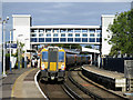
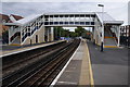
10
Staines station, Up platform 2005
View east, towards Richmond and Waterloo: ex-L&SWR Waterloo - Windsor/Reading Lines.
Image: © Ben Brooksbank
Taken: 26 Jun 2005
0.03 miles