IMAGES TAKEN NEAR TO
Richmond Crescent, STAINES-UPON-THAMES, TW18 2BX
Introduction
This page details the photographs taken nearby to Richmond Crescent, TW18 2BX by members of the Geograph project.
The Geograph project started in 2005 with the aim of publishing, organising and preserving representative images for every square kilometre of Great Britain, Ireland and the Isle of Man.

There are currently over 7.5m images from over14,400 individuals and you can help contribute to the project by visiting https://www.geograph.org.uk
Image Map
Images are licensed for reuse under creativecommons.org/licenses/by-sa/2.0
Notes
- Clicking on the map will re-center to the selected point.
- The higher the marker number, the further away the image location is from the centre of the postcode.
Image Listing (206 Images Found)
Images are licensed for reuse under creativecommons.org/licenses/by-sa/2.0
Image
Details
Distance
1
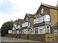
Laleham Road
The east side, between Richmond Road and the railway (part the railway bridge over the Thames can be seen on the far left).
Image: © Mike Quinn
Taken: 8 Aug 2018
0.02 miles
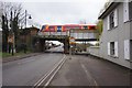
2
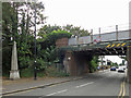
Railway bridge over Thames Street / Laleham Road
Shows the location of Image
Image: © Mike Quinn
Taken: 8 Aug 2018
0.03 miles
3
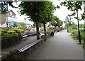
The Thames Path through Jubilee Gardens, Staines
The small Jubilee Memorial Gardens, opened in 1897 to commemorate the Diamond Jubilee of Queen Victoria in June the same year. The stone base of the cast iron lamp post is inscribed:
“This ground was purchased out of public subscriptions raised by the Staines Committee for the Commemoration of the Diamond Jubilee of Her Majesty Queen Victoria. June 1897”
You can also take a break here by having a seat in one of the old benches here. Most are really well preserved and have lasted the effects of time. They were all made in 1897 at the Johnson & Sharp Foundry which was situated next to the Blue Anchor, on the corner of the High Street and Thames Street.
Image: © Sean Davis
Taken: 20 Aug 2012
0.04 miles
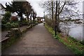
5
Rollers on riverside face of Railway Bridge abutment
The grey cylindrical object on the centre right is classified as a grade 2 listed building. There are three of these. They are early 19th century attached to the lower part of the buttresses of Staines Railway Bridge, on the towpath, to prevent the towropes of the barges from fraying and damage to the buttresses by wear. They were also be used as a gentle friction braking system if required.
Image: © Sean Davis
Taken: 9 Nov 2012
0.04 miles
6
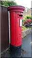
George V postbox on Laleham Road, Staines-upon-Thames
Postbox No. TW18 506.
Image: © JThomas
Taken: 27 May 2022
0.04 miles
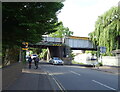
7

Victoria Gardens, Staines
Capturing the moment a train passes over the path and onto the bridge across the river.
Image: © David Martin
Taken: 30 Jan 2023
0.04 miles
10
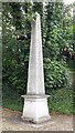
Coal tax boundary obelisk no.87, Thames Street
The location of this obelisk is shown in Image, Image and Image
There were originally nearly 280 coal tax posts located around London, of which about 210 are still extant; around 180 of these (85%) are 3 ft high white-painted square bollards with a pyramidal top, decorative raised bands, and the shield from the City of London’s arms. Photos of the coal tax posts on Geograph are at http://www.geograph.org.uk/search.php?i=86542993&page=1 .
There are just 13 stone obelisks of the type in the photo, all erected by railways that were opened before 1865. The posts were erected under the Coal and Wine Duties (Continuation) Act of 1861 to mark the points at which duty had to be paid on coal being transported to London. The boundary was set at that of the Metropolitan Police District, and the resulting revenue was used by the Corporation of the City of London to fund public works. For further info see http://www.coaldutyposts.org.uk/cityposts.html .
Image: © Mike Quinn
Taken: 8 Aug 2018
0.04 miles