IMAGES TAKEN NEAR TO
Eton Court, STAINES-UPON-THAMES, TW18 2AF
Introduction
This page details the photographs taken nearby to Eton Court, TW18 2AF by members of the Geograph project.
The Geograph project started in 2005 with the aim of publishing, organising and preserving representative images for every square kilometre of Great Britain, Ireland and the Isle of Man.

There are currently over 7.5m images from over14,400 individuals and you can help contribute to the project by visiting https://www.geograph.org.uk
Image Map
Images are licensed for reuse under creativecommons.org/licenses/by-sa/2.0
Notes
- Clicking on the map will re-center to the selected point.
- The higher the marker number, the further away the image location is from the centre of the postcode.
Image Listing (232 Images Found)
Images are licensed for reuse under creativecommons.org/licenses/by-sa/2.0
Image
Details
Distance

3
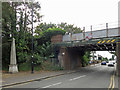
Railway bridge over Thames Street / Laleham Road
Shows the location of Image
Image: © Mike Quinn
Taken: 8 Aug 2018
0.10 miles
4

Offices, Thames Street
Shows the location of Image
Image: © Mike Quinn
Taken: 8 Aug 2018
0.10 miles
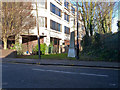
5
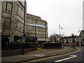
South Street at the junction of Laleham Road, Staines
The Bupa offices are on the left.
Image: © David Howard
Taken: 3 Feb 2013
0.10 miles
6
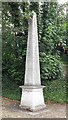
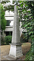
Coal tax boundary obelisk no.87, Thames Street
The location of this obelisk is shown in Image, Image and Image
There were originally nearly 280 coal tax posts located around London, of which about 210 are still extant; around 180 of these (85%) are 3 ft high white-painted square bollards with a pyramidal top, decorative raised bands, and the shield from the City of London’s arms. Photos of the coal tax posts on Geograph are at http://www.geograph.org.uk/search.php?i=86542993&page=1 .
There are just 13 stone obelisks of the type in the photo, all erected by railways that were opened before 1865. The posts were erected under the Coal and Wine Duties (Continuation) Act of 1861 to mark the points at which duty had to be paid on coal being transported to London. The boundary was set at that of the Metropolitan Police District, and the resulting revenue was used by the Corporation of the City of London to fund public works. For further info see http://www.coaldutyposts.org.uk/cityposts.html .
Image: © Mike Quinn
Taken: 8 Aug 2018
0.10 miles
7
Coal tax boundary obelisk no.87, Thames Street (2)
Image: © Mike Quinn
Taken: 8 Aug 2018
0.10 miles
8
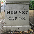
Coal tax boundary obelisk no.87, Thames Street - inscription
Image: © Mike Quinn
Taken: 8 Aug 2018
0.10 miles
9
Coal tax obelisk, Staines
This presumably applies to the railway, although not very visible from it down below. In crossing the Thames the railway passed from Surrey into Middlesex, and so crossed the boundary of the London coal tax zone. A grade II listed building.
Image: © Robin Webster
Taken: 17 Jan 2015
0.10 miles
10
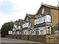
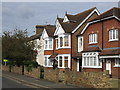
Laleham Road
The east side, between Richmond Road and the railway (part the railway bridge over the Thames can be seen on the far left).
Image: © Mike Quinn
Taken: 8 Aug 2018
0.10 miles