IMAGES TAKEN NEAR TO
Blacksmiths Lane, STAINES-UPON-THAMES, TW18 1UB
Introduction
This page details the photographs taken nearby to Blacksmiths Lane, TW18 1UB by members of the Geograph project.
The Geograph project started in 2005 with the aim of publishing, organising and preserving representative images for every square kilometre of Great Britain, Ireland and the Isle of Man.

There are currently over 7.5m images from over14,400 individuals and you can help contribute to the project by visiting https://www.geograph.org.uk
Image Map
Images are licensed for reuse under creativecommons.org/licenses/by-sa/2.0
Notes
- Clicking on the map will re-center to the selected point.
- The higher the marker number, the further away the image location is from the centre of the postcode.
Image Listing (114 Images Found)
Images are licensed for reuse under creativecommons.org/licenses/by-sa/2.0
Image
Details
Distance
1
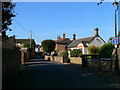
Blacksmith's Lane, Laleham
Leading down from the church to the river Thames.
Image: © Eirian Evans
Taken: 14 Oct 2011
0.01 miles
2
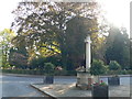
Laleham War Memorial
Laleham church is beyond the trees.
Image: © Eirian Evans
Taken: 14 Oct 2011
0.04 miles
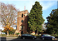

5

All Saints, Laleham
The red-brick tower of Laleham church.
Image: © Philip Halling
Taken: 29 Aug 2011
0.05 miles
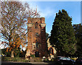
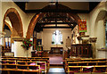
7

All Saints, Laleham - Stained glass window
Image: © John Salmon
Taken: 18 Nov 2016
0.05 miles
9
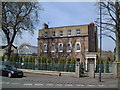
High Elms
This house is in a very prominent position in the village facing south along the road to Shepperton.
Image: © David Squire
Taken: 22 Apr 2006
0.05 miles
10

Yew Corner
One of the attractive houses in the village centre just to the east of High Elms.
Image: © David Squire
Taken: 22 Apr 2006
0.05 miles