IMAGES TAKEN NEAR TO
Thames Side, STAINES-UPON-THAMES, TW18 1SX
Introduction
This page details the photographs taken nearby to Thames Side, TW18 1SX by members of the Geograph project.
The Geograph project started in 2005 with the aim of publishing, organising and preserving representative images for every square kilometre of Great Britain, Ireland and the Isle of Man.

There are currently over 7.5m images from over14,400 individuals and you can help contribute to the project by visiting https://www.geograph.org.uk
Image Map
Images are licensed for reuse under creativecommons.org/licenses/by-sa/2.0
Notes
- Clicking on the map will re-center to the selected point.
- The higher the marker number, the further away the image location is from the centre of the postcode.
Image Listing (32 Images Found)
Images are licensed for reuse under creativecommons.org/licenses/by-sa/2.0
Image
Details
Distance
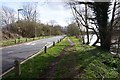
1
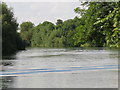
The River Thames upstream from Chertsey Lock
Image: © Mike Quinn
Taken: 11 Jul 2018
0.04 miles
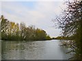
2
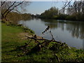
The Thames, Laleham
A tranquil view of the Thames on the first real day of spring. The M3 bridge can be seen in the far background.
Image: © Alan Hunt
Taken: 23 Mar 2011
0.04 miles
3
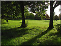
Laleham Park
Early morning sun in Laleham Park off Thameside.
Image: © Alan Hunt
Taken: 20 Oct 2014
0.05 miles
4
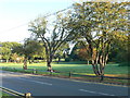
Laleham Park
Laleham was the ancestral home of the Lucan family.
Image: © Eirian Evans
Taken: 14 Oct 2011
0.08 miles
5
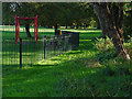
Play area, Laleham Park
The fenced play area in Laleham Park off Thameside.
Image: © Alan Hunt
Taken: 20 Oct 2014
0.08 miles
6

Autumn colour, Laleham Park
Autumn colour in Laleham Park off Thameside between Laleham and Chertsey.
Image: © Alan Hunt
Taken: 20 Oct 2014
0.09 miles
7
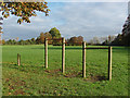
Climbing frames, Laleham Park
Climbing frames beside the large open expanse of Laleham Park.
Image: © Alan Hunt
Taken: 20 Oct 2014
0.09 miles
8
View upstream towards Laleham
Shot taken from a point just upstream from the M3 bridge. It is the last week of November, and the trees are fast losing their leaves.
For centuries, the Thames served as the boundary between the counties of Middlesex and Surrey. Boundary changes in the 1960's transferred much of west Middlesex to Surrey - including the stretch of riverbank from which this shot was taken.
Image: © Stefan Czapski
Taken: 25 Nov 2013
0.10 miles
10

Tow Path Grass with Common Daisy - Bellis perennis
The Common Daisy - Bellis perennis
Native flower of Europe excluding eastern Europe.
wiki : https://en.wikipedia.org/wiki/Bellis_perennis
Image: © James Emmans
Taken: 7 May 2016
0.14 miles