IMAGES TAKEN NEAR TO
Abbey Drive, STAINES-UPON-THAMES, TW18 1SR
Introduction
This page details the photographs taken nearby to Abbey Drive, TW18 1SR by members of the Geograph project.
The Geograph project started in 2005 with the aim of publishing, organising and preserving representative images for every square kilometre of Great Britain, Ireland and the Isle of Man.

There are currently over 7.5m images from over14,400 individuals and you can help contribute to the project by visiting https://www.geograph.org.uk
Image Map
Images are licensed for reuse under creativecommons.org/licenses/by-sa/2.0
Notes
- Clicking on the map will re-center to the selected point.
- The higher the marker number, the further away the image location is from the centre of the postcode.
Image Listing (113 Images Found)
Images are licensed for reuse under creativecommons.org/licenses/by-sa/2.0
Image
Details
Distance
1
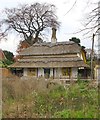
The Thatched Cottage, Laleham
Facing the river, but set back some distance from it, along Abbey Drive. I was quite surprised to find it listed by Pevsner, who suggests it may be of early 19th century date ('The Buildings of England' - included in both Surrey and Middlesex volumes).
To my eye, interesting details include the Tudor-style chimney and the honeycomb windows. There is also a thatchwork peacock on the roof (left-hand end).
Image: © Stefan Czapski
Taken: 25 Nov 2013
0.02 miles
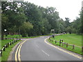
3
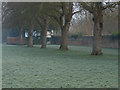
Tree line, Laleham Abbey grounds
A tree line by the former walled garden in the Laleham Abbey recreation ground on a cold winters morning. The Abbey used to be the home of the Lords Lucan until the 1950s when it was converted to a nursing home and the grounds beacame a public park.
Image: © Alan Hunt
Taken: 22 Jan 2015
0.05 miles
4
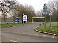
Thames Side car park
The car park entrance off Thames Side at Laleham.
Image: © Alan Hunt
Taken: 22 Jan 2015
0.08 miles
5
Burway Rowing Club
The colourful buildings belong to Burway Rowing Club, who have to take their boats across this road to reach the river at a landing stage where I am standing.
Image: © Graham Horn
Taken: 24 Aug 2008
0.08 miles
7
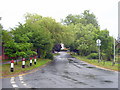
Ferry Lane Laleham
Seen from the junction with Thames Side.
Image: © Rod Allday
Taken: 22 Jun 2011
0.10 miles
8
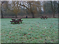
Thames Side picnic area
The picnic area near Thames Side car park with the edge of Laleham Park beyond.
Image: © Alan Hunt
Taken: 22 Jan 2015
0.10 miles
9
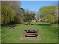
Thameside, Laleham
The picnic area by the Thameside car park looking towards the houses on Abbey Drive.
Image: © Alan Hunt
Taken: 23 Mar 2011
0.10 miles
10
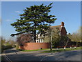
Thamesway, Laleham
A large cedar on the corner of Thamesway and Ferry Lane
Image: © Alan Hunt
Taken: 23 Mar 2011
0.10 miles