IMAGES TAKEN NEAR TO
New Farm Close, STAINES-UPON-THAMES, TW18 1RW
Introduction
This page details the photographs taken nearby to New Farm Close, TW18 1RW by members of the Geograph project.
The Geograph project started in 2005 with the aim of publishing, organising and preserving representative images for every square kilometre of Great Britain, Ireland and the Isle of Man.

There are currently over 7.5m images from over14,400 individuals and you can help contribute to the project by visiting https://www.geograph.org.uk
Image Map
Images are licensed for reuse under creativecommons.org/licenses/by-sa/2.0
Notes
- Clicking on the map will re-center to the selected point.
- The higher the marker number, the further away the image location is from the centre of the postcode.
Image Listing (7 Images Found)
Images are licensed for reuse under creativecommons.org/licenses/by-sa/2.0
Image
Details
Distance
3
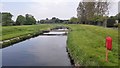
Thames Water Inlet River serving the Queen Mary Reservoir
Image: © James Emmans
Taken: 7 May 2016
0.09 miles
4
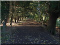
Footpath, Laleham
The footpath that runs across the fields between the Ashford Road and Berryscroft Road. The path is bordered by Leylandii, a relic of the nurseries that once occupied the site.
Image: © Alan Hunt
Taken: 16 Oct 2012
0.09 miles
5
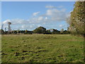
Fields near Laleham
The fields to the north of the footpath that runs from the Ashford Road to Berryscroft Road.
Image: © Alan Hunt
Taken: 16 Oct 2012
0.18 miles
6
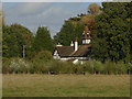
Field near Laleham
The fields between Laleham and Ashford with one of the houses on Ashford Road.
Image: © Alan Hunt
Taken: 16 Oct 2012
0.19 miles
7
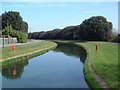
Intake Channel
This channel leads from the River Thames to the Queen Mary Reservoir, a distance of about one kilometre. As the reservoir water level is at least 10 metres higher than the river there is a pumping station at the eastern end.
Image: © David Squire
Taken: 22 Apr 2006
0.20 miles