IMAGES TAKEN NEAR TO
Thickthorne Lane, STAINES-UPON-THAMES, TW18 1LU
Introduction
This page details the photographs taken nearby to Thickthorne Lane, TW18 1LU by members of the Geograph project.
The Geograph project started in 2005 with the aim of publishing, organising and preserving representative images for every square kilometre of Great Britain, Ireland and the Isle of Man.

There are currently over 7.5m images from over14,400 individuals and you can help contribute to the project by visiting https://www.geograph.org.uk
Image Map
Images are licensed for reuse under creativecommons.org/licenses/by-sa/2.0
Notes
- Clicking on the map will re-center to the selected point.
- The higher the marker number, the further away the image location is from the centre of the postcode.
Image Listing (6 Images Found)
Images are licensed for reuse under creativecommons.org/licenses/by-sa/2.0
Image
Details
Distance
1
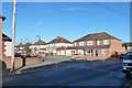
Houses on Ash Grove
Looking from Hazel Grove.
Image: © Robin Webster
Taken: 17 Jan 2015
0.13 miles
3
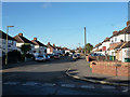
Laleham Methodist Church
Laleham Methodist Church on Edinburgh Drive
Image: © Shaun Ferguson
Taken: 20 Feb 2013
0.18 miles
4
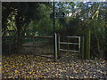
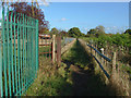
Footpath junction, Laleham
A metal kissing gate at the footpath junction near the Buckland Primary School.
Image: © Alan Hunt
Taken: 16 Oct 2012
0.20 miles
5
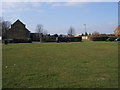
Footpath, Laleham
The footpath that runs alongside Buckland Primary School and Greenfield Recreation ground. For some reason there is a heavy duty steel rope running the length of the footpath along Greenfield Recreation Ground on the left.
Image: © Alan Hunt
Taken: 16 Oct 2012
0.24 miles
6
Old Staines council sign, Hurstdene Avenue
This has clearly faced the sun, as a little of the original black lettering can just be seen. The one at the other end of the green is still as original.
Image: © David Howard
Taken: 11 Jul 2010
0.24 miles