IMAGES TAKEN NEAR TO
Petersfield Road, STAINES-UPON-THAMES, TW18 1DF
Introduction
This page details the photographs taken nearby to Petersfield Road, TW18 1DF by members of the Geograph project.
The Geograph project started in 2005 with the aim of publishing, organising and preserving representative images for every square kilometre of Great Britain, Ireland and the Isle of Man.

There are currently over 7.5m images from over14,400 individuals and you can help contribute to the project by visiting https://www.geograph.org.uk
Image Map
Images are licensed for reuse under creativecommons.org/licenses/by-sa/2.0
Notes
- Clicking on the map will re-center to the selected point.
- The higher the marker number, the further away the image location is from the centre of the postcode.
Image Listing (26 Images Found)
Images are licensed for reuse under creativecommons.org/licenses/by-sa/2.0
Image
Details
Distance
1
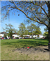
Strodes Crescent, Staines
A small green amongst the houses, with a kids' swing hanging off a tree branch.
Image: © Des Blenkinsopp
Taken: 10 May 2017
0.08 miles
8
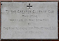
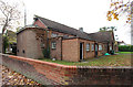
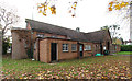
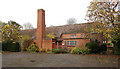
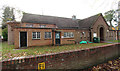
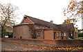
Christ Church, Church hall - Foundation stone
Image: © John Salmon
Taken: 15 Nov 2016
0.16 miles
9

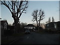
Christ Church, Kingston Road
Another shot of this striking 1960s church.
Image: © Des Blenkinsopp
Taken: 10 May 2017
0.17 miles