IMAGES TAKEN NEAR TO
SHEPPERTON, TW17 9WE
Introduction
This page details the photographs taken nearby to TW17 9WE by members of the Geograph project.
The Geograph project started in 2005 with the aim of publishing, organising and preserving representative images for every square kilometre of Great Britain, Ireland and the Isle of Man.

There are currently over 7.5m images from over14,400 individuals and you can help contribute to the project by visiting https://www.geograph.org.uk
Image Map
Images are licensed for reuse under creativecommons.org/licenses/by-sa/2.0
Notes
- Clicking on the map will re-center to the selected point.
- The higher the marker number, the further away the image location is from the centre of the postcode.
Image Listing (64 Images Found)
Images are licensed for reuse under creativecommons.org/licenses/by-sa/2.0
Image
Details
Distance
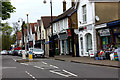
1
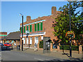
42/44 High Street, Shepperton
Formerly a bank, now to let as a shop.
Image: © Robin Webster
Taken: 1 Oct 2015
0.04 miles
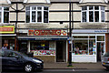
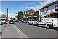
2
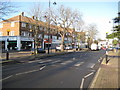
Shepperton: The High Street
Image is visible in the distance.
Image: © Nigel Cox
Taken: 7 Dec 2008
0.05 miles
3
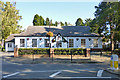
Village Hall, Shepperton
On the High Street.
Image: © Robin Webster
Taken: 1 Oct 2015
0.07 miles
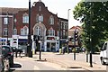
8
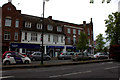
Shepperton: The Crossroads public house
Remove the modern single storey front extension and behind is one of the oldest buildings in this part of Shepperton, the former Railway Hotel, built shortly after the arrival of the railway in 1864 and certainly shown on the 1872 Edition of the Ordnance Survey mapping. At that time the railway station and the hotel were the only buildings in the area and it is evident that this part of Shepperton was subsequently developed solely because of the proximity of the railway route to London, the old village of Shepperton being some distance away to the south-west.
At some stage the pub became the Crossroads and it does now occupy a prominent location at the junction of Laleham Road, Old Charlton Road, Green Lane and the High Street.
Image: © Nigel Cox
Taken: 7 Dec 2008
0.10 miles
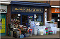
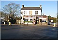
10
Station Approach, Shepperton
Business premises along Station Approach in Shepperton.
Image: © Alan Hunt
Taken: 28 Aug 2015
0.13 miles