IMAGES TAKEN NEAR TO
Church Road, SHEPPERTON, TW17 9JT
Introduction
This page details the photographs taken nearby to Church Road, TW17 9JT by members of the Geograph project.
The Geograph project started in 2005 with the aim of publishing, organising and preserving representative images for every square kilometre of Great Britain, Ireland and the Isle of Man.

There are currently over 7.5m images from over14,400 individuals and you can help contribute to the project by visiting https://www.geograph.org.uk
Image Map
Images are licensed for reuse under creativecommons.org/licenses/by-sa/2.0
Notes
- Clicking on the map will re-center to the selected point.
- The higher the marker number, the further away the image location is from the centre of the postcode.
Image Listing (167 Images Found)
Images are licensed for reuse under creativecommons.org/licenses/by-sa/2.0
Image
Details
Distance
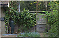
1
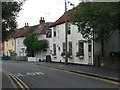
Winches Cottage, Old Shepperton
Late C16 and C17 cottages, extended and restored in C20.
Image: © Eirian Evans
Taken: 13 Oct 2011
0.01 miles
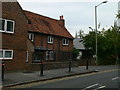
2

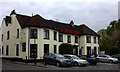
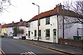
Church Road, Shepperton
The road that runs from Old Shepperton to the High Street.
Image: © Alan Hunt
Taken: 8 Jul 2013
0.01 miles
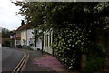
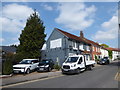
6
Edwinns Brasserie
This eating house is in Old Shepperton, on Chertsey Road.
No apostrophes are offered in the name of this establishment.
Image: © mike smith
Taken: 20 Jan 2012
0.04 miles