IMAGES TAKEN NEAR TO
Mervyn Road, SHEPPERTON, TW17 9HG
Introduction
This page details the photographs taken nearby to Mervyn Road, TW17 9HG by members of the Geograph project.
The Geograph project started in 2005 with the aim of publishing, organising and preserving representative images for every square kilometre of Great Britain, Ireland and the Isle of Man.

There are currently over 7.5m images from over14,400 individuals and you can help contribute to the project by visiting https://www.geograph.org.uk
Image Map
Images are licensed for reuse under creativecommons.org/licenses/by-sa/2.0
Notes
- Clicking on the map will re-center to the selected point.
- The higher the marker number, the further away the image location is from the centre of the postcode.
Image Listing (86 Images Found)
Images are licensed for reuse under creativecommons.org/licenses/by-sa/2.0
Image
Details
Distance
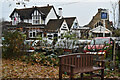
6
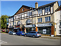
Lordsbridge House, High Street, Shepperton
Built 1927, according to the date over the central door to the residential part.
Image: © Robin Webster
Taken: 1 Oct 2015
0.05 miles
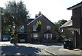
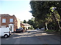
7
Outside the Shapla
An Asian restaurant on Russell Road, Shepperton.
Image: © Jonathan Billinger
Taken: 18 Nov 2016
0.05 miles
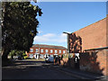
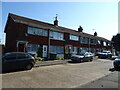
8
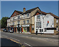
Shepperton High Street
A row of shops at the southern end of the High Street on the corner with Russell Road.
Image: © Alan Hunt
Taken: 8 Jul 2013
0.05 miles
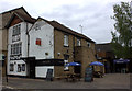
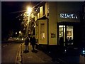
9
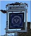
Sign for the Three Horseshoes, Shepperton
See Image] for context.
Image: © JThomas
Taken: 29 Jul 2022
0.06 miles