IMAGES TAKEN NEAR TO
Old Forge Crescent, SHEPPERTON, TW17 9BT
Introduction
This page details the photographs taken nearby to Old Forge Crescent, TW17 9BT by members of the Geograph project.
The Geograph project started in 2005 with the aim of publishing, organising and preserving representative images for every square kilometre of Great Britain, Ireland and the Isle of Man.

There are currently over 7.5m images from over14,400 individuals and you can help contribute to the project by visiting https://www.geograph.org.uk
Image Map
Images are licensed for reuse under creativecommons.org/licenses/by-sa/2.0
Notes
- Clicking on the map will re-center to the selected point.
- The higher the marker number, the further away the image location is from the centre of the postcode.
Image Listing (61 Images Found)
Images are licensed for reuse under creativecommons.org/licenses/by-sa/2.0
Image
Details
Distance
4
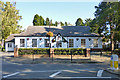
Village Hall, Shepperton
On the High Street.
Image: © Robin Webster
Taken: 1 Oct 2015
0.09 miles
5
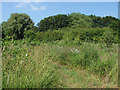
Scrub area off Renfree Way
The scrub area to the north of Renfree Way. This is a small area of open access land.
Image: © Alan Hunt
Taken: 8 Jul 2013
0.09 miles
6
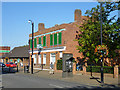
42/44 High Street, Shepperton
Formerly a bank, now to let as a shop.
Image: © Robin Webster
Taken: 1 Oct 2015
0.10 miles
7
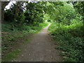
Footpath to Pool End
Footpath out from Shepperton to Pool End
Image: © Shaun Ferguson
Taken: 18 Jun 2008
0.10 miles
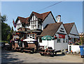
8
The Three Horseshoes, Shepperton
On School Lane, just off the High Street.
Image: © Robin Webster
Taken: 1 Oct 2015
0.12 miles
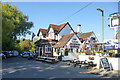
9
The Three Horseshoes
The Three Horseshoes public house on School Lane.
Image: © Alan Hunt
Taken: 8 Jul 2013
0.12 miles