IMAGES TAKEN NEAR TO
High Street, SHEPPERTON, TW17 9AY
Introduction
This page details the photographs taken nearby to High Street, TW17 9AY by members of the Geograph project.
The Geograph project started in 2005 with the aim of publishing, organising and preserving representative images for every square kilometre of Great Britain, Ireland and the Isle of Man.

There are currently over 7.5m images from over14,400 individuals and you can help contribute to the project by visiting https://www.geograph.org.uk
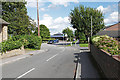
Image Map
Images are licensed for reuse under creativecommons.org/licenses/by-sa/2.0
Notes
- Clicking on the map will re-center to the selected point.
- The higher the marker number, the further away the image location is from the centre of the postcode.
Image Listing (74 Images Found)
Images are licensed for reuse under creativecommons.org/licenses/by-sa/2.0
Image
Details
Distance
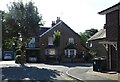
1
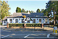
Village Hall, Shepperton
On the High Street.
Image: © Robin Webster
Taken: 1 Oct 2015
0.01 miles
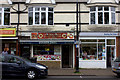
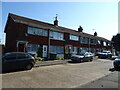
4
42/44 High Street, Shepperton
Formerly a bank, now to let as a shop.
Image: © Robin Webster
Taken: 1 Oct 2015
0.04 miles
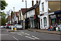
6
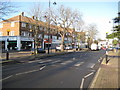
Shepperton: The High Street
Image is visible in the distance.
Image: © Nigel Cox
Taken: 7 Dec 2008
0.11 miles
9
Glebeland gardens, Shepperton
The eastern end of Glebeland Gardens looking towards the recreation ground.
Image: © Alan Hunt
Taken: 28 Aug 2015
0.13 miles
10
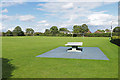
Recreation ground, Shepperton
The recreation ground off Glebeland Gardens in Shepperton.
Image: © Alan Hunt
Taken: 28 Aug 2015
0.14 miles