IMAGES TAKEN NEAR TO
Upper Halliford Road, SHEPPERTON, TW17 8SQ
Introduction
This page details the photographs taken nearby to Upper Halliford Road, TW17 8SQ by members of the Geograph project.
The Geograph project started in 2005 with the aim of publishing, organising and preserving representative images for every square kilometre of Great Britain, Ireland and the Isle of Man.

There are currently over 7.5m images from over14,400 individuals and you can help contribute to the project by visiting https://www.geograph.org.uk
Image Map
Images are licensed for reuse under creativecommons.org/licenses/by-sa/2.0
Notes
- Clicking on the map will re-center to the selected point.
- The higher the marker number, the further away the image location is from the centre of the postcode.
Image Listing (42 Images Found)
Images are licensed for reuse under creativecommons.org/licenses/by-sa/2.0
Image
Details
Distance
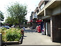
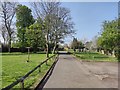
2
Upper Halliford
Village centre with flats above the street level shops and ample on street parking.
Image: © Colin Smith
Taken: 14 Dec 2011
0.03 miles
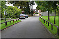
3
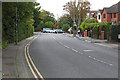
Upper Halliford Road
Looking south along Upper Halliford Road as it enters the village from the bypass roundabout.
Image: © Alan Hunt
Taken: 24 Sep 2015
0.05 miles
4
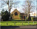
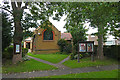
Upper Halliford: St Andrew's Baptist Church
The church is in the Upper Halliford Conservation Area on Upper Halliford Road. It is shown on the Ordnance Survey map of 1913 so dates from before then. The church's website is here http://sabc.org.uk/
Image: © Nigel Cox
Taken: 7 Dec 2008
0.06 miles
5
St Andrew's Baptist Church, Upper Halliford
The church to the west of Upper Halliford Road.
Image: © Alan Hunt
Taken: 24 Sep 2015
0.06 miles
6
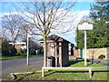
Upper Halliford Green
Bus stop, shelter and village sign on a triangular scrap of grass at Upper Halliford.
Image: © Colin Smith
Taken: 14 Dec 2011
0.06 miles
7
Upper Haliford - Freeman Close
A short cul-de-sac off the Upper Halliford Green.
Image: © James Emmans
Taken: 10 Apr 2020
0.06 miles
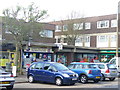
8
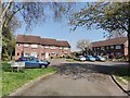
Upper Halliford Green
The residential cul de sac off the Upper Halliford Road.
Image: © Alan Hunt
Taken: 24 Sep 2015
0.07 miles
10
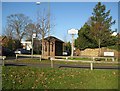
Upper Halliford green
The village sign and a wooden bus shelter on the green are seen here. The bus shelter was erected in 2000 on the initiative of the Alan Freeman Trust with the support of Spelthorne Borough Council.
Image: © Nigel Cox
Taken: 7 Dec 2008
0.08 miles