IMAGES TAKEN NEAR TO
Kelly Close, SHEPPERTON, TW17 8RL
Introduction
This page details the photographs taken nearby to Kelly Close, TW17 8RL by members of the Geograph project.
The Geograph project started in 2005 with the aim of publishing, organising and preserving representative images for every square kilometre of Great Britain, Ireland and the Isle of Man.

There are currently over 7.5m images from over14,400 individuals and you can help contribute to the project by visiting https://www.geograph.org.uk
Image Map
Images are licensed for reuse under creativecommons.org/licenses/by-sa/2.0
Notes
- Clicking on the map will re-center to the selected point.
- The higher the marker number, the further away the image location is from the centre of the postcode.
Image Listing (60 Images Found)
Images are licensed for reuse under creativecommons.org/licenses/by-sa/2.0
Image
Details
Distance
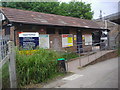
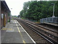
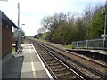
5
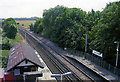
Upper Halliford station, 2005
View SW from A244 Cadbury Road bridge, towards Shepperton: ex-L&SWR branch from Waterloo via Kingston/Strawberry Hill; opened 5/44, a Halt until 5/69.
Image: © Ben Brooksbank
Taken: 26 Jun 2005
0.05 miles
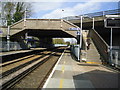
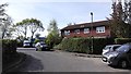
8
Upper Halliford Road
A terrace of houses in a truncated section of Upper Halliford Road, now bypassed by a new section of the A244 on a flyover over the railway and M3 motorway. The bollarded section in the background leads to Upper Halliford station.
Image: © Ian Capper
Taken: 10 Nov 2010
0.05 miles
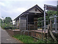
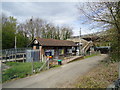
10
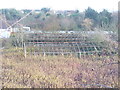
Dereliction by Nursery Road
Presumably Nursery Road in Upper Halliford took its name from this nursery which is obviously now not in use,
Image: © Colin Smith
Taken: 14 Dec 2011
0.06 miles