IMAGES TAKEN NEAR TO
Western Drive, SHEPPERTON, TW17 8HL
Introduction
This page details the photographs taken nearby to Western Drive, TW17 8HL by members of the Geograph project.
The Geograph project started in 2005 with the aim of publishing, organising and preserving representative images for every square kilometre of Great Britain, Ireland and the Isle of Man.

There are currently over 7.5m images from over14,400 individuals and you can help contribute to the project by visiting https://www.geograph.org.uk
Image Map
Images are licensed for reuse under creativecommons.org/licenses/by-sa/2.0
Notes
- Clicking on the map will re-center to the selected point.
- The higher the marker number, the further away the image location is from the centre of the postcode.
Image Listing (23 Images Found)
Images are licensed for reuse under creativecommons.org/licenses/by-sa/2.0
Image
Details
Distance
1
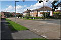
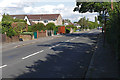
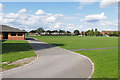
Western Drive, Shepperton
Western Drive with the junction to West Way on the right.
Image: © Alan Hunt
Taken: 28 Aug 2015
0.02 miles
2
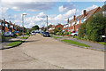
Western Drive, Shepperton
Looking north along Western Drive in the housing estates to the south of Green Lane.
Image: © Alan Hunt
Taken: 28 Aug 2015
0.04 miles
3

Western Drive, Shepperton
One of the roads in the housing estate between the High Street and Gaston Bridge Road.
Image: © Alan Hunt
Taken: 28 Aug 2015
0.04 miles
4
Nell Gwynne Avenue, Shepperton
Looking north along Nell Gwynne Avenue towards the junction with Green Lane.
Image: © Alan Hunt
Taken: 28 Aug 2015
0.07 miles
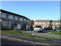
5
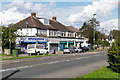
The Shepperton Superstore
The local general store on Green Lane.
Image: © Alan Hunt
Taken: 28 Aug 2015
0.12 miles
6
Green Lane, Shepperton
The road from Shepperton High Street towards the Gaston Bridge Road.
Image: © Alan Hunt
Taken: 28 Aug 2015
0.13 miles
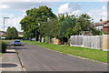
8
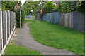
Walkway, Shepperton
The walkway between Lyndsey Drive and Western Drive.
Image: © Alan Hunt
Taken: 28 Aug 2015
0.14 miles
9
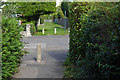
Footpath crossing point
The point where the footpath from Manygate Lane crosses Lyndsay Drive on its way to Western Drive.
Image: © Alan Hunt
Taken: 28 Aug 2015
0.14 miles
10
Playing fields, Thamesmead school
The view across the playing fields from the footpath between Manygate Lane and Lyndsey Drive.
Image: © Alan Hunt
Taken: 28 Aug 2015
0.16 miles