IMAGES TAKEN NEAR TO
Lois Drive, SHEPPERTON, TW17 8BE
Introduction
This page details the photographs taken nearby to Lois Drive, TW17 8BE by members of the Geograph project.
The Geograph project started in 2005 with the aim of publishing, organising and preserving representative images for every square kilometre of Great Britain, Ireland and the Isle of Man.

There are currently over 7.5m images from over14,400 individuals and you can help contribute to the project by visiting https://www.geograph.org.uk
Image Map
Images are licensed for reuse under creativecommons.org/licenses/by-sa/2.0
Notes
- Clicking on the map will re-center to the selected point.
- The higher the marker number, the further away the image location is from the centre of the postcode.
Image Listing (43 Images Found)
Images are licensed for reuse under creativecommons.org/licenses/by-sa/2.0
Image
Details
Distance

2
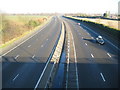
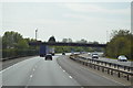
M3 Motorway near Shepperton
The M3 Motorway sweeps diagonally across this grid square separating Shepperton from Shepperton Green. This is viewed looking towards London from the Laleham Road bridge.
Image: © Nigel Cox
Taken: 7 Dec 2008
0.10 miles
3

The Bell Inn
Pub in residential street.
Image: © James Emmans
Taken: 27 Jun 2015
0.11 miles

6

Electricity substation (?) in Laleham Road, Shepperton
Image: © Chris
Taken: 17 Jul 2017
0.18 miles
7
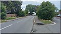
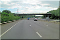
Shepperton - Laleham Road
A bridge over the M3 is in the distance.
Image: © Peter Whatley
Taken: 27 Jul 2023
0.19 miles