IMAGES TAKEN NEAR TO
Walnut Tree Road, SHEPPERTON, TW17 0SA
Introduction
This page details the photographs taken nearby to Walnut Tree Road, TW17 0SA by members of the Geograph project.
The Geograph project started in 2005 with the aim of publishing, organising and preserving representative images for every square kilometre of Great Britain, Ireland and the Isle of Man.

There are currently over 7.5m images from over14,400 individuals and you can help contribute to the project by visiting https://www.geograph.org.uk
Image Map
Images are licensed for reuse under creativecommons.org/licenses/by-sa/2.0
Notes
- Clicking on the map will re-center to the selected point.
- The higher the marker number, the further away the image location is from the centre of the postcode.
Image Listing (5 Images Found)
Images are licensed for reuse under creativecommons.org/licenses/by-sa/2.0
Image
Details
Distance
1
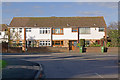
Houses in Charlton
A modern terrace of houses in Charlton Road opposite Hetherington Road
Image: © Ian Capper
Taken: 10 Nov 2010
0.04 miles
2
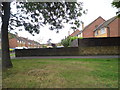
Houses on Almond Close from Charlton Road
Image: © David Howard
Taken: 26 Aug 2013
0.08 miles
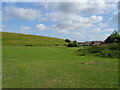
5
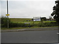
Charlton Road, Upper Halliford
Overlooking Queen Mary Reservoir. All the local reservoirs along the Thames here have animals grazing around the edge, there are horses and cows on the flat fields and sheep on the slopes which you can just see.
Image: © David Howard
Taken: 2 Sep 2012
0.24 miles