IMAGES TAKEN NEAR TO
Glen Close, SHEPPERTON, TW17 0EJ
Introduction
This page details the photographs taken nearby to Glen Close, TW17 0EJ by members of the Geograph project.
The Geograph project started in 2005 with the aim of publishing, organising and preserving representative images for every square kilometre of Great Britain, Ireland and the Isle of Man.

There are currently over 7.5m images from over14,400 individuals and you can help contribute to the project by visiting https://www.geograph.org.uk
Image Map
Images are licensed for reuse under creativecommons.org/licenses/by-sa/2.0
Notes
- Clicking on the map will re-center to the selected point.
- The higher the marker number, the further away the image location is from the centre of the postcode.
Image Listing (63 Images Found)
Images are licensed for reuse under creativecommons.org/licenses/by-sa/2.0
Image
Details
Distance
1
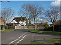
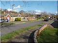
Stewart Avenue, Littleton
The junction of Stewart Avenue with Elliott Gardens. Stewart Avenue was developed in the late 1960s.
Image: © Alan Hunt
Taken: 2 Mar 2015
0.03 miles
2
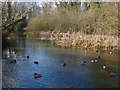
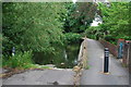
River Ash, Littleton
Looking west along the river from the footbridge at the end of Watersplash Road.
Image: © Alan Hunt
Taken: 2 Mar 2015
0.07 miles
3
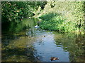
The Splash, River Ash, Shepperton
This is an area locally called The Splash. It is where Watersplash Road crosses the River Ash. A short low footbridge makes it possible to ford the river at this shallow point.
The photographer was standing on the bridge.
The river is often only a few inches deep at this point, so, in the past, before the footbridge was built, a horse and cart could have crossed here. This is a useful shortcut in the area.
Image: © Sheel
Taken: 23 Aug 2005
0.08 miles
4
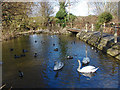
Swans on the Ash
Swans (and a few ducks) on the River Ash by the footbridge that runs from Waterspalsh Road To Littleton Farm
Image: © Alan Hunt
Taken: 2 Mar 2015
0.08 miles
5
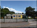
Ford at Shepperton Green
This ford on the River Ash is found close to Shepperton Film Studios on Watersplash Road.
Image: © John Walton
Taken: 16 Jun 2013
0.09 miles
6
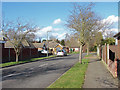
Stewart Avenue, Littleton
A residential road in the housing estate to the east of Squires Bridge Road.
Image: © Alan Hunt
Taken: 2 Mar 2015
0.11 miles
8
Stewart Avenue, Littleton
Looking north from Ash Road along this residential road in Littleton village.
Image: © Alan Hunt
Taken: 2 Mar 2015
0.13 miles
10
New Road, Littleton
The road running from Littleton to Carlton Village with the schoolhouse on the left.
Image: © Alan Hunt
Taken: 2 Mar 2015
0.15 miles