IMAGES TAKEN NEAR TO
Broad Oak, SUNBURY-ON-THAMES, TW16 7RQ
Introduction
This page details the photographs taken nearby to Broad Oak, TW16 7RQ by members of the Geograph project.
The Geograph project started in 2005 with the aim of publishing, organising and preserving representative images for every square kilometre of Great Britain, Ireland and the Isle of Man.

There are currently over 7.5m images from over14,400 individuals and you can help contribute to the project by visiting https://www.geograph.org.uk
Image Map
Images are licensed for reuse under creativecommons.org/licenses/by-sa/2.0
Notes
- Clicking on the map will re-center to the selected point.
- The higher the marker number, the further away the image location is from the centre of the postcode.
Image Listing (6 Images Found)
Images are licensed for reuse under creativecommons.org/licenses/by-sa/2.0
Image
Details
Distance
1
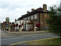
The Hare and Hounds, Vicarage Road
A Fuller's house.
Image: © Robin Webster
Taken: 16 Sep 2012
0.20 miles
2
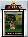
The Hare and Hounds - inn sign
For the rest of the pub, see Image This sign is identical to another Fuller's pub of the same name on Windmill Lane near Osterley Park - see Image
Image: © Robin Webster
Taken: 16 Sep 2012
0.20 miles
3
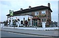
The Hare and Hounds, Sunbury Common
The grid square is in the middle of the road here for about 50 yards
Image: © David Howard
Taken: 26 Nov 2018
0.21 miles
4
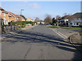
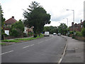
Beechwood Avenue
Beechwood Avenue passing Ashridge Way
Image: © Shaun Ferguson
Taken: 20 Feb 2013
0.21 miles
6
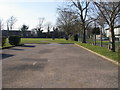
King George's Field
King George's Field by Groveley Road
Image: © Shaun Ferguson
Taken: 20 Feb 2013
0.23 miles