IMAGES TAKEN NEAR TO
Fairlawns, SUNBURY-ON-THAMES, TW16 6QR
Introduction
This page details the photographs taken nearby to Fairlawns, TW16 6QR by members of the Geograph project.
The Geograph project started in 2005 with the aim of publishing, organising and preserving representative images for every square kilometre of Great Britain, Ireland and the Isle of Man.

There are currently over 7.5m images from over14,400 individuals and you can help contribute to the project by visiting https://www.geograph.org.uk
Image Map
Images are licensed for reuse under creativecommons.org/licenses/by-sa/2.0
Notes
- Clicking on the map will re-center to the selected point.
- The higher the marker number, the further away the image location is from the centre of the postcode.
Image Listing (60 Images Found)
Images are licensed for reuse under creativecommons.org/licenses/by-sa/2.0
Image
Details
Distance
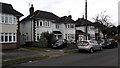
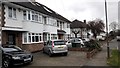
1
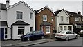
Fairlawns off Croysdale Avenue
Small hidden Cul de sac.
Image: © James Emmans
Taken: 20 Mar 2016
0.03 miles
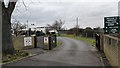
5
London Irish Rugby Club
Newly built and opened in 2015
http://www.london-irish-amateur.co.uk/club-house.html
Image: © James Emmans
Taken: 27 Jun 2015
0.08 miles
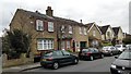
6
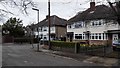
Parkwood Grove off Croysdale Avenue
Small side road cul de sac.
Image: © James Emmans
Taken: 20 Mar 2016
0.08 miles
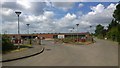
7
London Irish Rugby Club Car Park
Completely new development with large car park and sports club buildings.
Image: © James Emmans
Taken: 27 Jun 2015
0.08 miles
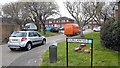
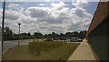
9
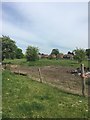
South limb of Stratton Road
The south limb of Stratton Road overlooks this beautiful much bigger than this ex-landfill
Image: © Ad-lad
Taken: 8 May 2020
0.09 miles